In today’s fast-changing urban landscape, GIS in land use and zoning analysis for better city planning plays a vital role in shaping smarter, more livable cities. Whether it’s managing population growth, conserving green spaces, or optimizing infrastructure, city planners increasingly depend on GIS to make informed decisions. This article explores how GIS tools enhance zoning accuracy, especially when spatial conflicts like land use overlaps occur—and how MAPOG simplifies the entire process.
Key Concept: Understanding GIS in Zoning and Land Use
Before diving deeper, let’s clarify what GIS actually does here. GIS allows users to collect, analyze, and visualize spatial data. In zoning and land use planning, it helps in:
- Mapping existing land use
- Detecting conflicting zones
- Supporting data-driven planning decisions
The core idea is to ensure every inch of city land is used effectively—without unintentional overlaps or misuse.
Discover how MAPOG’s GIS-based platform transforms land price data into intuitive visualizations, empowering real estate professionals with actionable market insights. Learn the step-by-step process to create detailed land price maps, enhancing strategic decision-making in the real estate industry.
Steps to GIS in land use and zoning analysis for better city planning
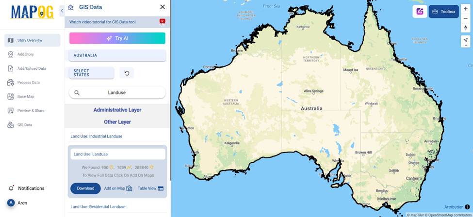
1. Visualizing Land Use Layers with GIS
One of the first steps in land use planning is to layer different zones—residential, commercial, industrial, and green zones. MAPOG enables users to add and visualize data directly on interactive maps through GIS data. For example, city planners can visualize an area’s zoning layout using shapefiles or GeoJSON data formats.
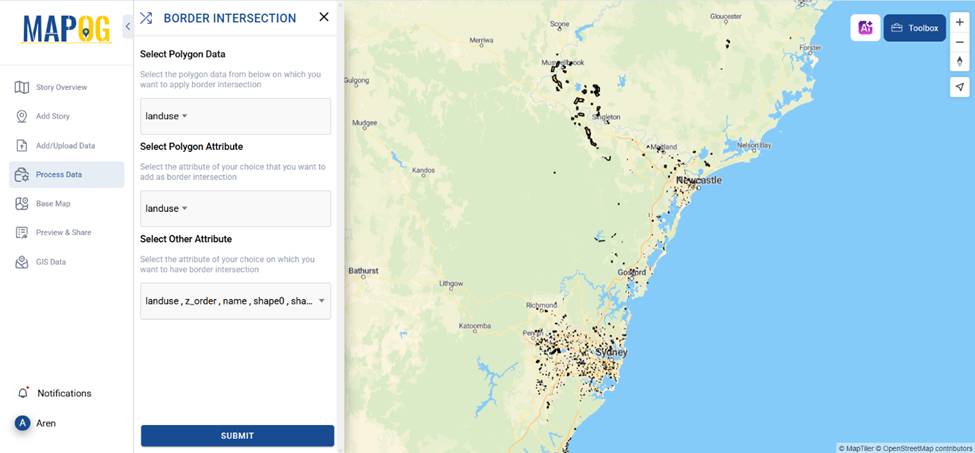
2. Border Intersection Analysis: Detecting Conflicts
An essential part of zoning analysis is identifying areas where different land uses conflict. After adding land use data in the Border intersection tool through process data and ran a border intersection analysis. This allowed us to spot overlapping zones—such as a residential block extending into an industrial area.
Real-World Application: How Cities Use GIS Smartly
Let’s say a municipality wants to expand green parks but ensure they don’t cut into high-density residential areas. By using GIS in land use and zoning analysis, planners can overlay vegetation maps with zoning data. With spatial queries, they can filter areas where green space expansion is viable.
In another case, urban developers use zoning maps overlaid with transportation routes to decide where to place new commercial hubs, making business districts more accessible.
With MAPOG, GIS in land use and zoning analysis becomes easier to analyze both visually and technically—especially through its ability to handle layers, attribute filters, and real-time updates.
Why Accurate Zoning Maps Matter
A small zoning mistake can lead to noise complaints, traffic congestion, or legal disputes. By using GIS:
- Planners ensure better compliance with urban regulations.
- Environmental impact assessments become more accurate.
- Citizens enjoy a more livable and well-structured city environment.
GIS doesn’t just make maps—it helps make smarter decisions.
Explore how GIS mapping tools can transform fragmented farmland into productive, equitable agricultural landscapes. This article guides you through using MAPOG’s merge and split tools for effective land consolidation and redistribution.
GIS Data Used
Conclusion
From identifying zoning overlaps to turning point data into polygons, GIS in land use and zoning analysis for better city planning is a game-changer for modern urban development. MAPOG simplifies this complex process, offering intuitive tools like Border Intersection Tool that bring clarity and accuracy to planning workflows.
So next time you work on a zoning project or urban development study, think about how visual storytelling with GIS could elevate your impact.
Have you ever used GIS tools to spot zoning conflicts? Share your experience in the comments!
Here are some other blogs you might be interested in