In the vibrant state of urban landscapes, the integration of Geographic Information Systems (GIS) with MAPOG Map Analysis, a powerful platform has paved the way for an article titled “Creating Connectivity: A Spatial Analysis of Urban Accessibility.” This article focuses on harnessing the potential of spatial analysis to unravel key insights into the connectivity of bus stops and healthcare facilities across diverse communities.
Key Concept to Creating Connectivity: A Spatial Analysis of Urban Accessibility
The central theme here involves harnessing spatial tools to explore and establish urban connectivity. Through the use of isochrones and proximity analysis, the analysis unveils patterns around bus stops and healthcare facilities, presenting 20-minute travel areas and strategic development zones. The emphasis on integrating public transportation and healthcare proximity reveals valuable opportunities for strategic real estate development and urban planning. A data link providing access to the datasets used in this analysis will be provided at the end of this narrative.
Below, we outline the steps to leverage the capabilities of MAPOG’s Map Analysis, an intuitive and user-friendly tool.
This systematic process seamlessly guides us through the creation of 20-minute isochrones and the execution of proximity analysis around bus stops. Let’s delve into each step, ensuring a smooth and insightful navigation through this analytical journey.
Step 1: Add GIS Data
The initial step involves importing Bus Stop Data and Hospital Data into the MAPOG platform. This sets the foundation for the subsequent spatial analysis.
- Click on the “Add Upload” button and choose “Upload Vector File”.
- you can see the “Upload Vector File” tool open on the right side of your screen. here upload your required data. and click on the “Upload” button.

Step 2: Isochrone Creation
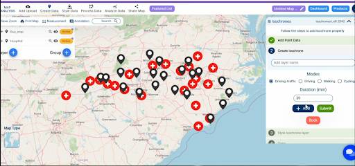
With datasets in place, the article guides users through the creation of 20-minute isochrones around bus stops. This step facilitates a clear visualization of areas accessible within a 20-minute travel time.
- Click on the “Process Data” option then choose “Isochrones”.
- You can see the “Isochrones” tool successfully open on the right side. here you have to choose the Bus stop layer and set the duration and click on the “Submit” button.

Step 3: Enhancing Visualization
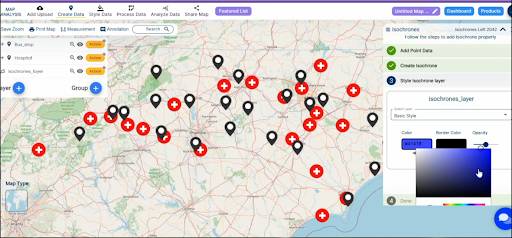
To enhance clarity, the article demonstrates modifying Isochrone colors on the map, ensuring a comprehensive and visually appealing representation.
- Click on the “Basic Style” button and change the colour of isochrones. and click on the “Save Style” Option.

Step 4: Proximity Analysis
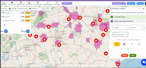
Utilizing MAPOG’s powerful proximity analysis tool, the article showcases the precise identification of hospitals within the 20-minute isochrones around bus stops.
- Click on the “Analyze Data” button and choose “Two Layer”.
- Now choose the Finding features “Hospital” and select Feature “Bus Stop Isochrones”. and click on the “Next” Button.
- here You have set the Field and option and click on the “Get Result” option.

Result and Analyzing:
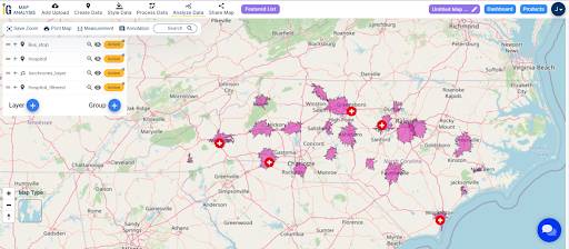
As the spatial analysis unfolds, the map comes to life, revealing hospitals strategically positioned within the 20-minute isochrones. This result sets the stage for in-depth analysis and unveils valuable insights.

Finding:
Analyzing the results brings forth valuable insights. Optimal urban development opportunities emerge, healthcare accessibility is enhanced, and strategic real estate hotspots become evident.
- Optimal Urban Development: Areas within the 20-minute isochrones around bus stops present opportunities for optimal urban development in . Decision-makers can prioritize infrastructure development to enhance connectivity.
- Enhanced Healthcare Accessibility: Pinpointing hospitals within proximity to key transportation hubs significantly improves healthcare accessibility. This has a direct impact on emergency response planning and community well-being.
- Strategic Real Estate Opportunities: The spatial analysis uncovers strategic opportunities for real estate development. Areas seamlessly connected by public transportation and located near healthcare facilities become prime locations.
- Value Addition to Properties: Real estate developers can leverage this data to add substantial value to properties. Proximity to essential services, combined with efficient transportation, becomes a selling point, attracting potential buyers and investors.
- Informed Decision-Making: The findings empower urban planners and developers with data-driven insights, enabling informed decision-making for shaping urban landscapes that prioritize accessibility and quality of life for residents in .
This spatial analysis journey has illuminated the intricate web of urban accessibility in . The creation of 20-minute isochrones around bus stops, coupled with proximity analysis to identify hospitals, has unearthed invaluable insights. As we navigate the future armed with these spatial revelations, the urban landscape evolves into a carefully woven tapestry of connectivity and intelligence. The findings empower decision-makers, offering a roadmap for optimized urban planning and strategic real estate development. This journey serves as a testament to the transformative power of spatial analysis in shaping a more accessible and vibrant future for the diverse communities.
Link of the Data:
Explore the data further through our GIS Data product, uncovering valuable information for in-depth analysis and understanding.