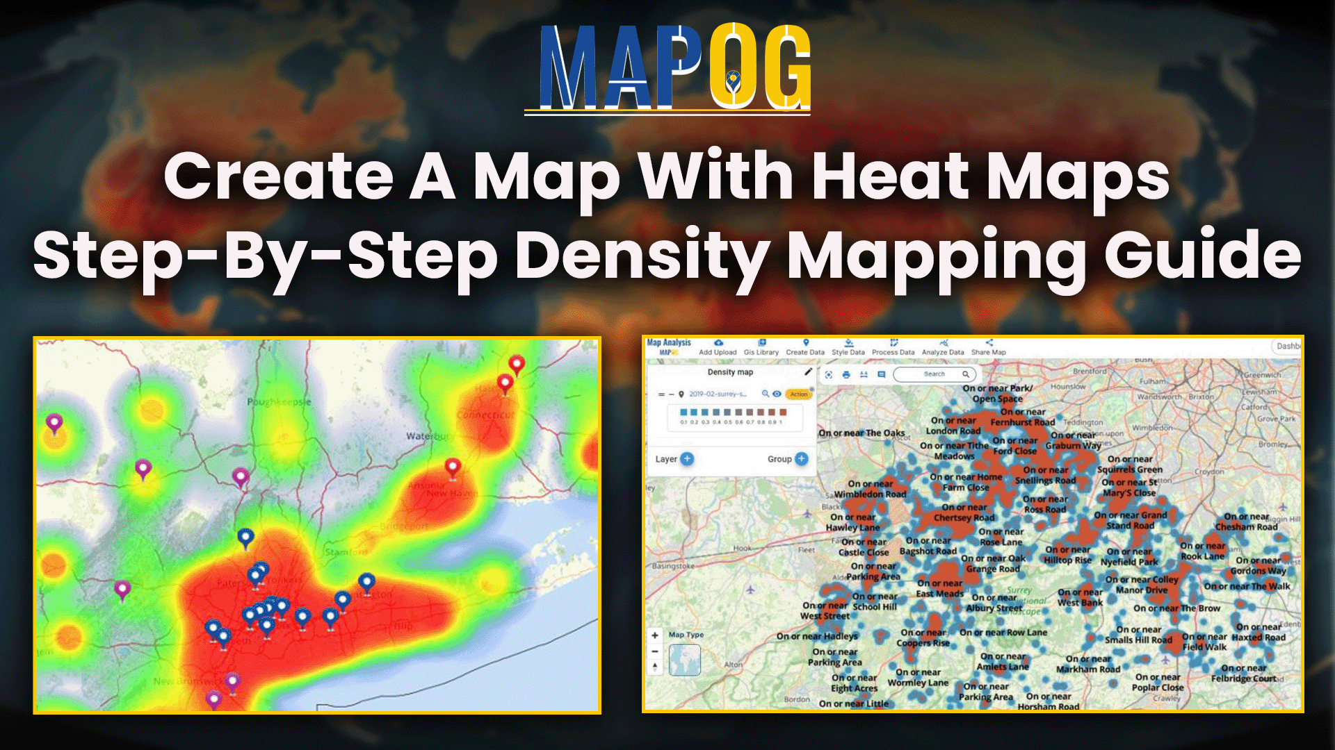
Creating GIS Solutions for Urban Agriculture Map
Insights into farmland distribution, urban encroachment risks, agricultural potential, and mitigation strategies for urban agriculture.
Welcome to our exploration of optimizing bank branch locations using MAPOG‘s map analysis tool. In this article, we’ll dive into the straightforward process of selecting the best locations for bank branches. By harnessing the power of MAPOG, we aim to simplify the decision-making process, ensuring easy access to banking services for all. Join us as … Read more
In today’s era of rapid urbanization and the push for sustainable transportation, the accessibility of charging stations for electric vehicles (EVs) has emerged as a critical consideration. In this article, we delve into the importance of evaluating the accessibility of charging stations, employing the powerful methodology of MAPOG MAP Analysis. By harnessing this innovative approach, … Read more
In the dynamic realm of e-commerce, optimizing last-mile delivery is paramount for customer satisfaction and market competitiveness. E-Commerce Logistics Isochrone Analysis Mapping Strategy, facilitated by tools like MAPOG, plays a pivotal role in refining logistics operations and elevating delivery efficiency. By strategically mapping e-commerce delivery networks using isochrone analysis, businesses can gain valuable insights into … Read more
In the realm of ‘Petrol Pump Availability: Empowering Access’, MAPOG stands as a powerful tool, offering insights that can redefine our understanding of spatial dynamics. In a world constantly moving, access to petrol pumps is paramount. At MAPOG, we’re dedicated to providing a comprehensive solution for visualizing and analyzing Petrol Pump Accessibility: A Spatial Analysis. … Read more
In the realm of modern travel, airports not just serve as gateways to destinations but also operate as hubs for retail exploration. Nevertheless, maneuvering through shopping adventures in close proximity to airports can prove overwhelming. This is precisely where MAPOG steps in—a GIS platform that revolutionizes the exploration of premium shopping experiences near airports. This … Read more
In the dynamic world of outdoor recreation and tourism, finding ideal camping spots within a region can be challenging. Using shapefiles for the region and point files for camping locations, proximity analysis becomes a formidable tool. In this use case, we explore MAPOG Map Analysis for identifying optimal Camping Spots: Points in Polygon Analysis. Join … Read more
Analysis crime data with MAPOG. Uncover patterns and trends for informed decision-making with our powerful map analysis tool.
Simplify logistics and navigation with MAPOG’s airport mapping tools. Upload Excel files, enhance visual clarity, and revolutionize air travel planning.
MAPOG Route Compass streamlines construction travel, offering precise route planning and efficient navigation for engineering professionals.