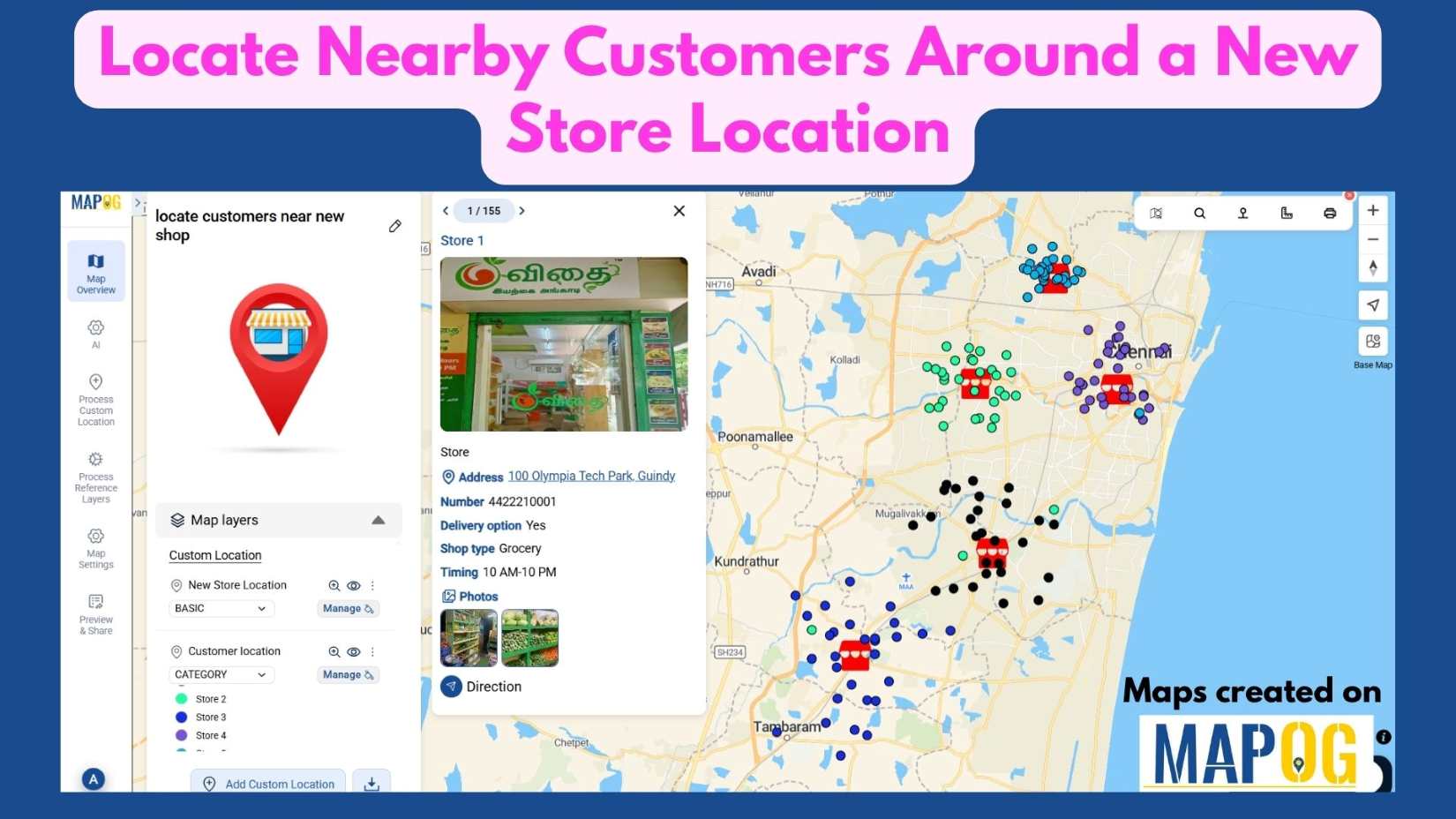
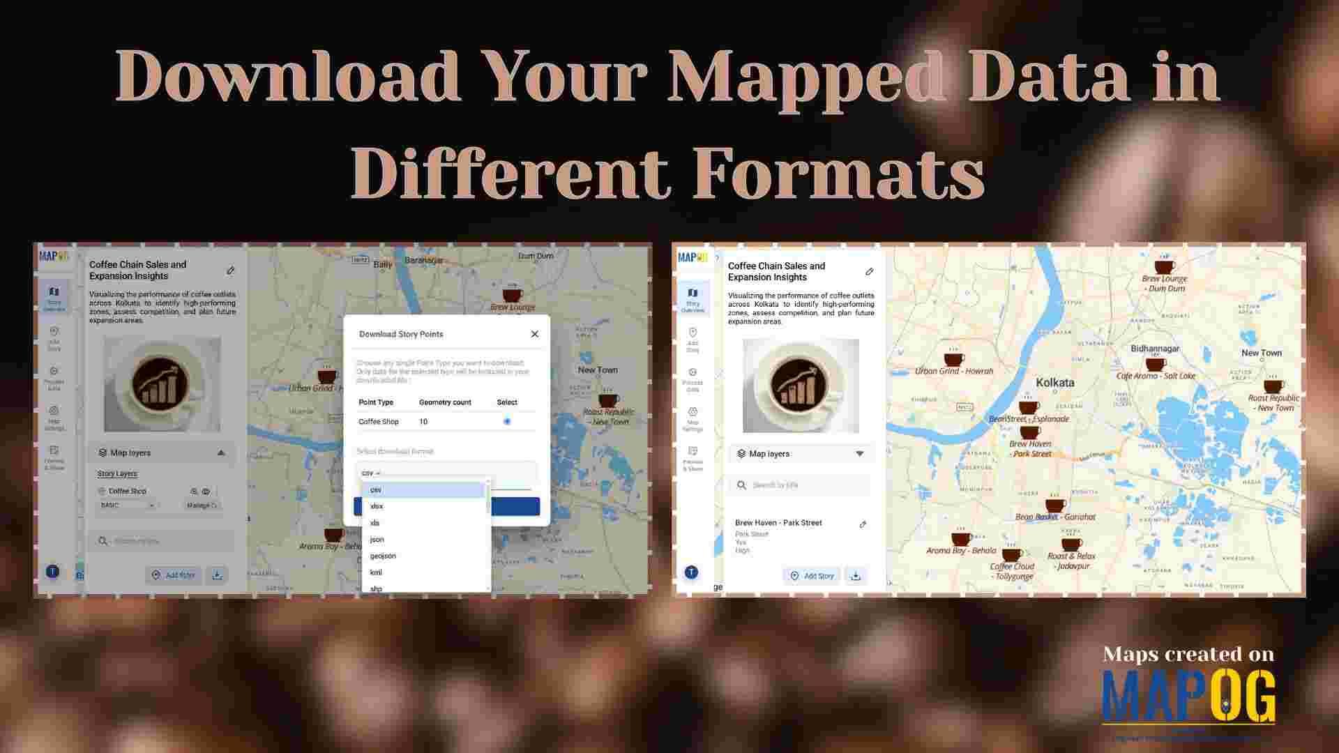
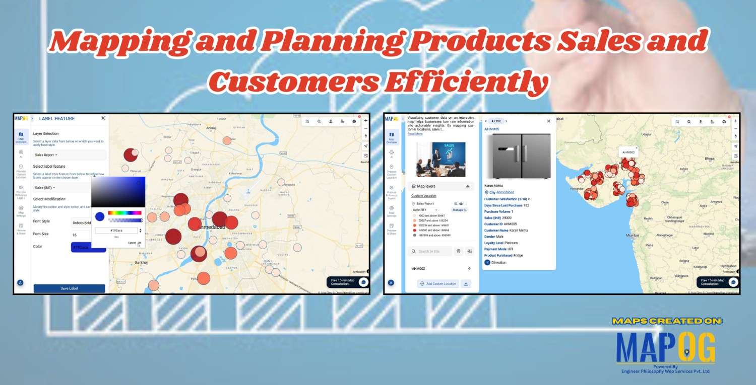
City Plannig

Interactive Property Hunt Map

How to Organise Your Property Hunt: Pin Live Locations, Add Photos, and Manage All Details on One Interactive Map

Searching for a new home can be both exciting and overwhelming. With endless property listings, scattered notes, and various amenities to consider, it’s easy to feel lost in the process. That’s where an Interactive Property Hunt Map becomes a game-changer. By using smart tools like MAPOG, you can visually organize your entire home search—pinning property … Read more

Ambulance Accessibility & Response Time Analysis

In life-threatening emergencies, every second counts. Consequently, ambulances must reach patients quickly. However, in many cities, emergency response times are slowed down by poor planning, traffic congestion, or lack of infrastructure. This is precisely where Geographic Information Systems (GIS) step in. Platforms like MAPOG are transforming how cities visualize Ambulance Accessibility & Response all without … Read more

GIS in Identifying High-Growth Areas for Real Estate Investment

GIS in Identifying High-Growth Areas for Real Estate Investment

In today’s fast-evolving urban landscape, identifying the right location for real estate investment is both a science and a strategy. GIS helps in Identifying High-Growth Areas is a go-to approach for investors and planners aiming to make informed, data-backed decisions. From analyzing transportation access to mapping nearby amenities, GIS adds a new level of depth … Read more

Clean Cities in India: Mapping with a GIS Perspective

Clean Cities in India: Mapping with a GIS Perspective

Mapping Clean Cities in India is a GIS Perspective which explores how geospatial tools turn sanitation rankings into spatial insight. As India’s cities evolve, sustainability—and cleanliness in particular—has become central to public health and urban development. When evaluating the cleanest city in India, Swachh Survekshan survey offers annual rankings, the “where” behind success often goes … Read more

Mapping Noise Pollution Levels in Cities Using Heat Maps and Buffer Tools

Mapping Noise Pollution Levels: Using Heat Maps and Buffer Tools

Noise pollution is an increasingly critical yet often overlooked environmental challenge. In urban areas, it stems primarily from traffic, construction, railways, and industrial activities. Fortunately, with the rise of Geographic Information Systems (GIS) especially tools like heat maps and buffer zones for Mapping Noise Pollution Levels. We can now visualize these invisible pollutants. As a … Read more

How to Map EV Charging Stations Using GIS: A Step-by-Step Guide

Mapping EV charging stations is a crucial step for planners aiming to develop smart, data-driven electric vehicle infrastructure. As electric mobility accelerates, GIS platforms like MAPOG enable users to visualize charging station locations clearly, identify gaps in coverage, and prioritize investments. Consequently, using modern web-based mapping tools, planners and analysts transform spreadsheets into actionable maps—showing … Read more

How GIS is Improving Traffic Management and Road Safety  

Traffic congestion and road accidents are major challenges in urban areas, leading to economic losses, increased pollution, and safety risks. As a result, Geographic Information Systems (GIS) have emerged as a powerful tool for analyzing, visualizing, and optimizing traffic flow while enhancing road safety. As a result of integrating spatial data, traffic authorities can identify … Read more

mapping sewage and drainage systems

Mapping Sewage and Drainage Systems Using Cross Intersection Tool

Nowadays, mapping sewage and drainage systems has become a smarter and more data-driven approach to urban planning and environmental safety. In particular, mapping such infrastructures helps identify pollution risks, optimise maintenance, and prevent disasters. One powerful way to achieve this is through the use of spatial tools like buffer zones and cross-intersection methods. By doing … Read more

Power Grid and Infrastructure mapping and planning using GIS

Power Grid and Infrastructure mapping and planning using GIS

Geographic Information Systems (GIS) are revolutionizing power grid mapping and infrastructure planning. By linking geospatial intelligence with electrical grid data, GIS enables utility companies and energy planners to visualize, assess, and optimize power distribution networks. Furthermore, it supports everything from the planning of substations and transmission lines to the ongoing monitoring of grid performance. As … Read more

GIS helps in solar energy site suitability and analysis

How GIS helps in Solar Energy Site Suitability and Analysis

In today’s renewable energy movement, GIS helps in solar energy site suitability and analysis by providing precision, clarity, and data-driven decisions. This blog unpacks how Geographic Information Systems are transforming how we identify optimal solar farm locations, ensuring both efficiency and environmental harmony. Through a practical example using real GIS tools, you’ll discover how layered … Read more