Health

District-Wise Disability Population Analysis Using Heat Maps Easy Insights & Mapping

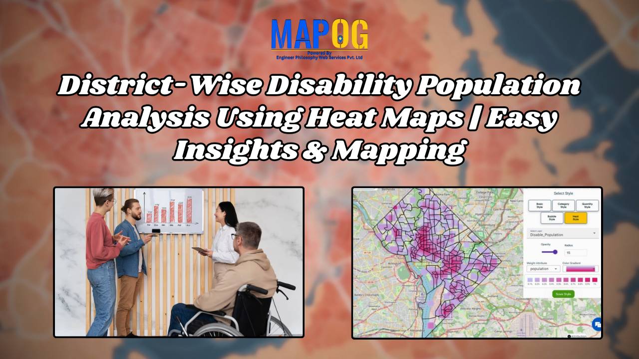
District-Wise Disability Population Analysis Using Heat Maps | Easy Insights & Mapping

Dive into the world of Disability Population Heat Map Analysis, where advanced mapping techniques provide district-wise insights with ease. By leveraging heat maps, we simplify complex data interpretation, offering a clear visual representation of disability distribution. This approach empowers policymakers, urban planners, and organizations to make informed decisions for improved accessibility and resource allocation. Explore … Read more

How to use GIS for Mapping Disease Affected Area

 Geographic Information System is an emerging field that combines spatial analysis, statistical modeling and data visualization. We can create maps by pinpointing the location of disease outbreak by using a “point to polygon tool” and help us lineate the affected area smoothly and effortlessly. Key concept  Analysis of disease affected areas by using point to … Read more

Best GIS Tools for Healthcare Analysis: Enhancing Accessibility & Resource Allocation

Healthcare is an industry in which the basis for many decisions could be driven by data. For instance, healthcare services can be effectively analyzed with spatial insight into resource allocation and disease distribution, which, in turn, determines the accessibility of care. Therefore, this article presents some of the best GIS tools available for healthcare professionals … Read more

How to Use GIS Grid Tools for Mapping Healthcare Services and Improving Access

In the quest to enhance health care service delivery, GIS provides a robust platform for mapping and analyzing health care services across different regions. Utilizing grid-based mapping techniques in GIS allows for a detailed. The equal-area analysis of service distribution with highlighting areas. Mapping Health Care Services: Utilizing Grid Tools in GIS, This article outlines … Read more

Mapping Disease Outbreaks: How GIS Enhances Surveillance and Control

In recent years, the importance of disease surveillance has been underscored by various global health challenges, including pandemics and emerging infectious diseases. Disease surveillance plays a pivotal role in public health management, enabling the timely detection, monitoring, and control of infectious diseases. MAPOG is a powerful tool for health authorities to augment traditional surveillance methods. … Read more

Split Polygon

Creating Public Health Maps: Splitting and Dividing Polygons for Targeted Interventions

What is a Split Polygon tool? The Split Polygon tool is a function that allows to divide a polygon into multiple sections along a specified line. This tool enables analysts to dissect complex geometries into simpler components, facilitating more precise spatial analysis and data management. This article delves into the significance of the MAPOG Split … Read more

mapping heat index

Mapping Air Quality Index: Air Pollution Monitoring

In this article, we examine the utilization of MAP OG’s MAP ANALYSIS techniques for visualizing Air Quality Index (AQI) data and Mapping Air Quality Index. Discover how GIS tools offer insights into pollution patterns, aiding informed decision-making for environmental health. Through sophisticated mapping techniques, we uncover nuanced insights into air pollution distribution. Explore how these … Read more