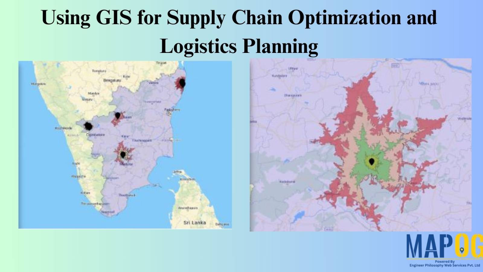
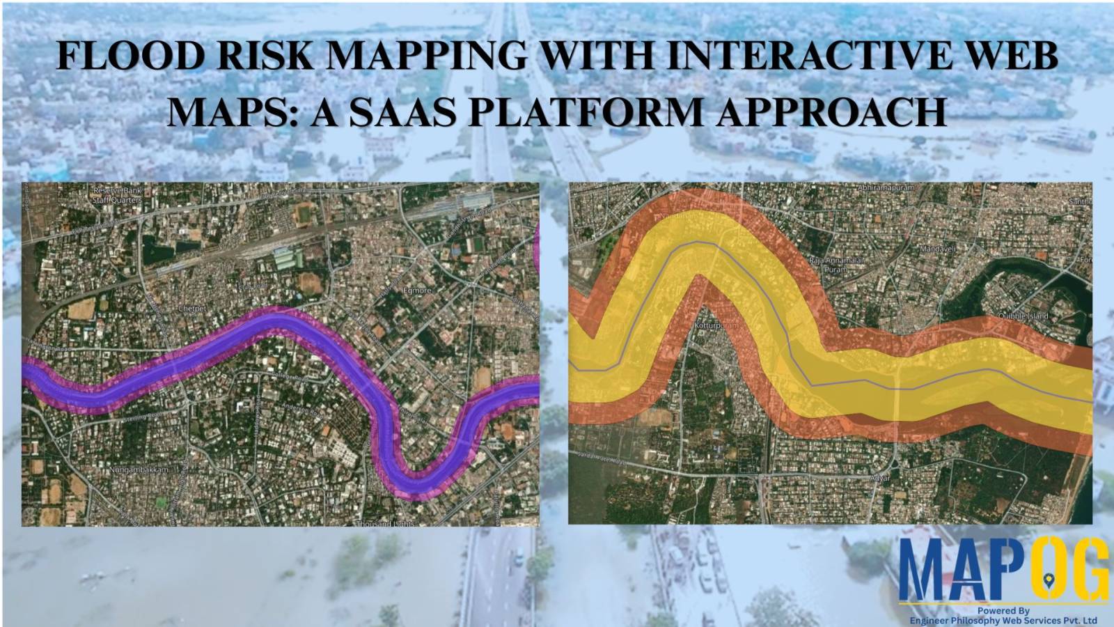
MAPOG Analysis

Wildlife Corridor Planning: Using GIS Cross Intersection Analysis for Safe Migration

By identifying crucial junctions with human infrastructure, “Wildlife Corridor Planning using Cross Intersection in MAPOG” guarantees safe animal migration and habitat connectivity. This strategy protects biodiversity while reducing conflict. Key Concepts MAPOG’s Cross Intersection tool enables conservationists and planners to pinpoint critical intersections where wildlife corridors intersect infrastructure, enabling targeted mitigation strategies. Download MAPOG App … Read more

How to Use GIS Grid Tools for Mapping Healthcare Services and Improving Access

In the quest to enhance health care service delivery, GIS provides a robust platform for mapping and analyzing health care services across different regions. Utilizing grid-based mapping techniques in GIS allows for a detailed. The equal-area analysis of service distribution with highlighting areas. Mapping Health Care Services: Utilizing Grid Tools in GIS, This article outlines … Read more

How to Choose the Perfect Retail Shop Location Using Isochrone Maps – Boost Foot Traffic & Sales

Choosing the perfect spot for your retail shop can make all the difference.  With MAPOG Map Analysis, you can use the Isochrone tool to identify areas with the best customer accessibility.  Isochrone maps help you visualize travel times, ensuring you find locations that maximize foot traffic and sales potential. Explore smarter site selection with MAPOG’s … Read more

County-Wise Income Analysis: Thematic Mapping for Better Insights & Decision-Making

The difficulty of visualizing and analyzing earnings data is addressed in “Easy Income Analysis Using Thematic Maps for County-Wise Insights,” where we use quantity thematic styling to depict earnings across several geographic counties. Key Concepts Using quantity thematic design to visually display the income distribution across geographic blocks, the county-Wise Earnings Analysis in MAPOG offers … Read more

How to Use Isochrone Maps for Business Growth & Location Planning

In today’s fast-paced world, businesses need tools that help them make data-driven decisions. Isochrone maps, which visualize areas accessible within a certain time or distance, can be a game-changer. They provide insights into customer reach, delivery zones, and more. This article explores how isochrone maps can benefit your business and use MAPOG to create meaningful … Read more

Mastering the Merge Polygon Tool: Simplifying Protected Areas Management with GIS

What is Merge Polygon tool? The Merge Polygon tool is a functionality that enables the combination or consolidation of adjacent or overlapping polygons into a single, cohesive polygonal feature. This tool is essential for spatial data processing and analysis, allowing users to simplify complex datasets, resolve geometric inconsistencies, and streamline data representation. This article delves … Read more

Forest Management: Step-by-Step Guide to Split Polygon for Effective Maps

In ‘Forest Management Using Split Polygon Tool,’ we employ MAPOG Map Analysis to divide forested regions into equal parts, optimizing resource allocation and conservation efforts for sustainable forest management. Key Concepts MAPOG is an outstanding tool for creating interactive and innovative maps. We can employ this tool to divide forested regions into equal parts, optimizing … Read more