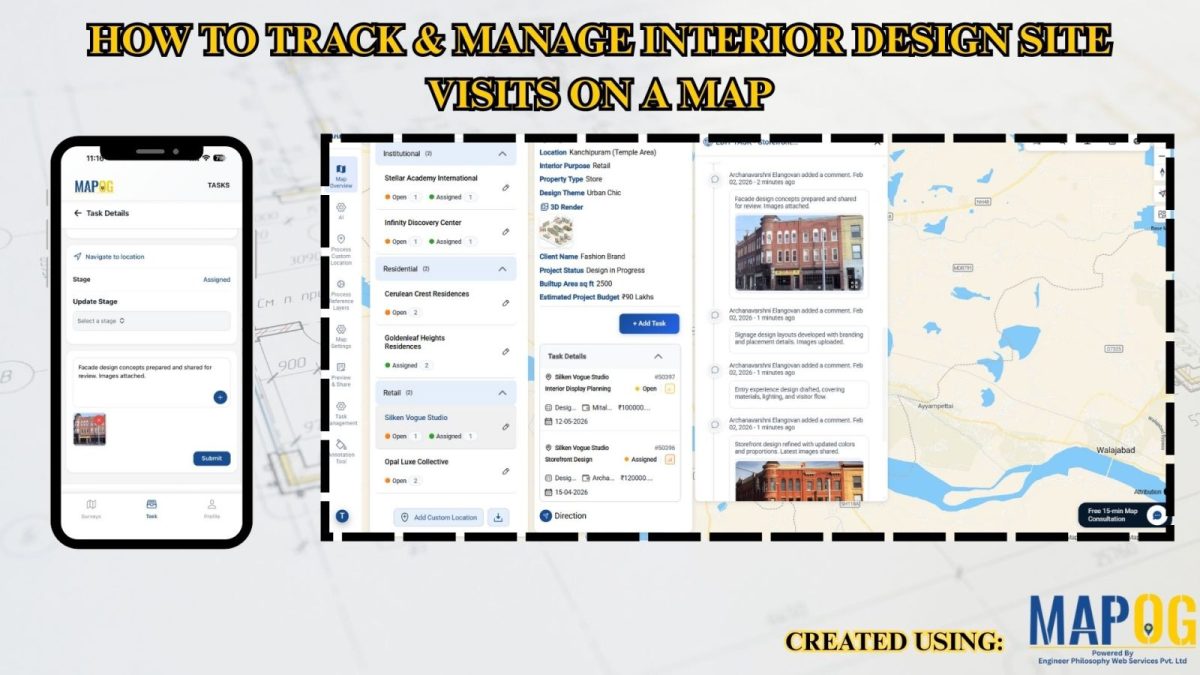
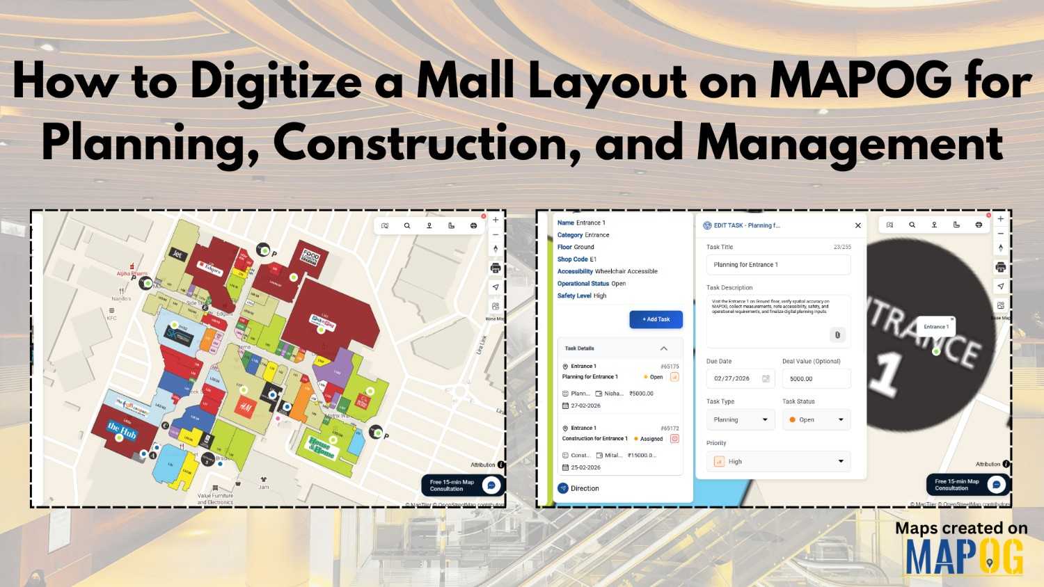
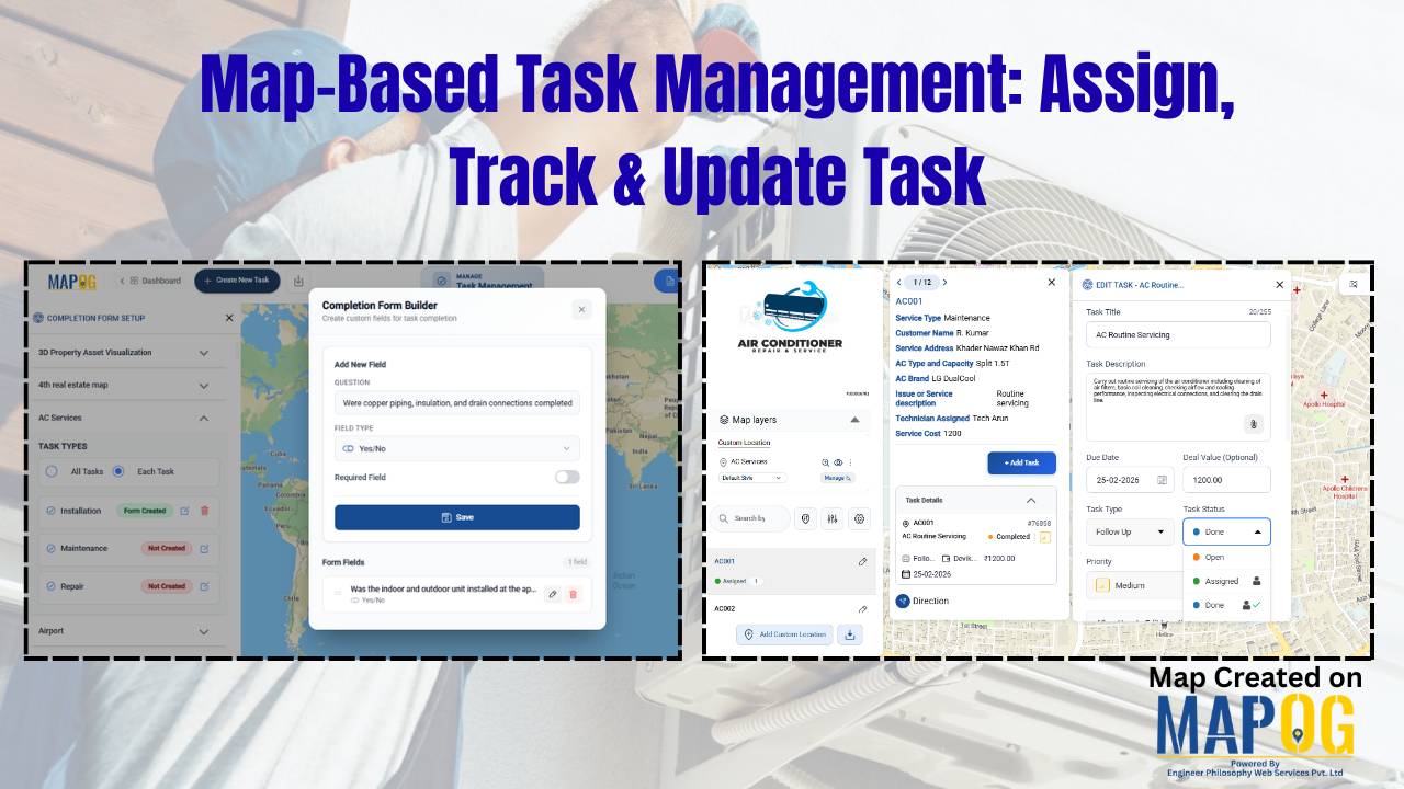
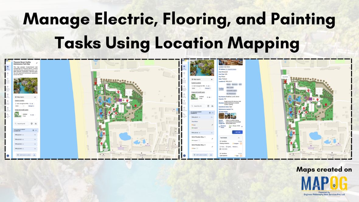
MAPOG Analysis

Creating a Story Map of Monuments and Share or Embed It Anywhere

A Story Map of Monuments using MAPOG transforms how we explore cultural heritage. Instead of static lists, it offers a visual journey through India’s architectural legacy—organized by district or state. Whether you’re promoting tourism, documenting history, or supporting heritage conservation, a story Map of Monuments using MAPOG brings depth and context that traditional formats can’t … Read more

How to Create Interactive Maps Without Any Technical Skills

How to Create and Embed Live Maps on Your Website in Minutes

In today’s data-driven world, learning how to create and embed live maps into your blog or Website can instantly boost engagement and clarity. Whether you’re showcasing public services, identifying urban gaps, or promoting inclusivity, interactive maps transform static content into immersive, insightful experiences no GIS skills required. With MAPOG, a no-code mapping tool, anyone can … Read more

Create interactive maps using MAPOG without technical skills

Create Interactive Maps Without Any Technical Skills – A Visual Guide

Creating interactive maps no longer requires technical skills or expertise in geographic information systems. Today, even individuals without a background in GIS can visualise and analyse spatial data to better understand real-world issues. Whether you’re a teacher, student, or policy planner, interactive maps can powerfully communicate patterns, challenges, and opportunities in education, healthcare, infrastructure, and … Read more

Top places to Visit Across India – Visual Travel Guide on Map

India is more than a destination it’s a vibrant journey through culture, nature, and heritage. With the MAPOG code-free mapping platform, you can effortlessly transform your travel plans or blog into an interactive visual experience, highlighting top places to visit across India. From sacred sites to scenic wonders, bring India’s diversity to life all in … Read more

Mapping Borewell Locations Near Rivers and Lakes with GIS-Based Tools

Mapping borewell locations near rivers and lakes is not only vital for understanding groundwater dependencies but also essential for ensuring sustainable usage. In fact, in regions where surface water and groundwater interact closely, analyzing borewell proximity to these natural water bodies becomes even more crucial. Moreover, with the help of GIS-based tools like MAPOG, users … Read more

“A digital map highlighting water-scarce villages and nearby water sources in India using GIS tools, illustrating buffer zones, village boundaries, and water infrastructure.”

GIS-Based Mapping of Water-Scarce Villages and Nearest Water Sources

Water scarcity continues to challenge many rural areas across India. With shifting climate patterns, population pressures, and the overuse of natural resources, numerous villages face both seasonal and long-term water stress. However, Mapping Groundwater Concentration through GIS presents a powerful approach to this issue. By visualizing the availability and distribution of subsurface water, it becomes … Read more

How to Create Map, Share, and Embed Your Retail Business Locations

How to Create Map, Share, and Embed Your Retail Business Locations

In today’s hyper-connected marketplace, visibility is everything—and digital maps are becoming essential tools for retail success. Mapping, sharing, and embedding your retail store locations using  MAPOG enables business owners and marketers to showcase their store presence with clarity and precision. Whether you operate a single boutique or a nationwide chain, geospatial tools help you Visualise, … Read more

Ambulance Accessibility & Response Time Analysis

In life-threatening emergencies, every second counts. Consequently, ambulances must reach patients quickly. However, in many cities, emergency response times are slowed down by poor planning, traffic congestion, or lack of infrastructure. This is precisely where Geographic Information Systems (GIS) step in. Platforms like MAPOG are transforming how cities visualize Ambulance Accessibility & Response all without … Read more

GIS in Identifying High-Growth Areas for Real Estate Investment

GIS in Identifying High-Growth Areas for Real Estate Investment

In today’s fast-evolving urban landscape, identifying the right location for real estate investment is both a science and a strategy. GIS helps in Identifying High-Growth Areas is a go-to approach for investors and planners aiming to make informed, data-backed decisions. From analyzing transportation access to mapping nearby amenities, GIS adds a new level of depth … Read more

Country Wise UNESCO Guide: Top Heritage Spots on a Map

Create Countrywise UNESCO Map: Top Heritage Spots Guide

Create a country-wise UNESCO Guide Map that highlights both cultural brilliance and natural wonders. On the other hand, by integrating GIS tools, this project enhances public awareness, encourages responsible tourism, and supports heritage preservation. It offers users an educational and immersive storytelling experience that makes exploring global heritage sites more accessible, insightful, and engaging. Key … Read more