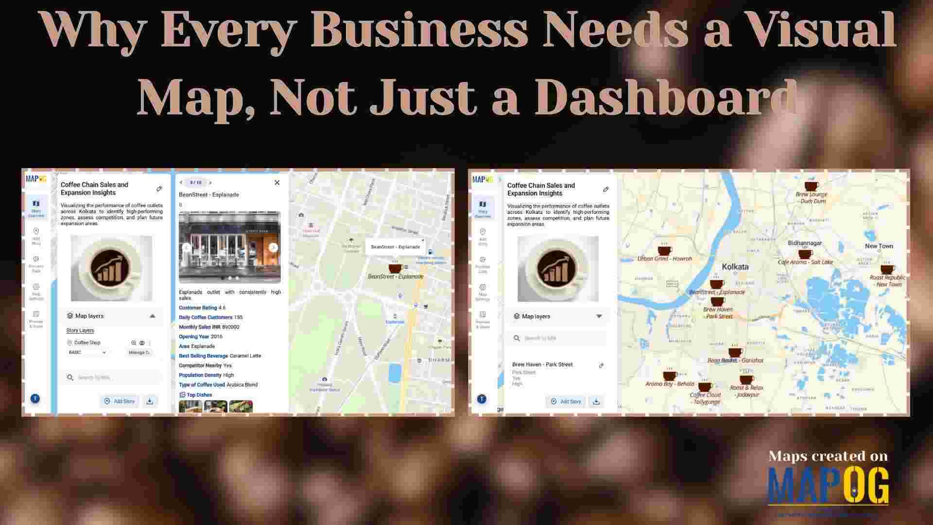
Uncategorized

Mapping Waste Disposal Sites with GIS for Clean Cities

In fast-growing cities, mapping waste disposal sites with GIS is becoming essential to public health and sustainability. As waste volumes rise, understanding where and how it’s managed is key to building cleaner, more efficient cities. This project uses MAPOG, a cloud-based spatial mapping platform, to visualize key waste disposal sites—ranging from major landfills to Refuse … Read more

How to Map CCTV Cameras and Crime Zones with GIS Tools

How to Map CCTV Cameras and Crime Zones with GIS Tools

In today’s fast-evolving urban landscape, public safety has become a top priority for city planners and law enforcement agencies. One of the most effective ways to enhance security is through the strategic placement of CCTV cameras — and this is where Geographic Information System (GIS) tools play a transformative role. By mapping surveillance infrastructure alongside … Read more

The Ultimate Guide to Uploading GIS Data Formats (CSV, KML, Shapefile)

Uploading GIS data is the crucial first step in any spatial analysis workflow. Whether for urban planning, environment, infrastructure, or disaster response, clean and structured data ensures accuracy in representing real-world features and relationships. Using correct formats allows mapping software to interpret boundaries and attributes effectively. MAPOG, a leading cloud-based GIS platform, supports various formats … Read more

Story Map Online Free: How to Create One Without GIS Skills

Learn how to create a story map online free using MAPOG—no GIS skills needed, just intuitive storytelling with images, text, and location. Whether you’re showcasing heritage sites, tracking environmental changes, or exploring social patterns, Story Maps convert static information into engaging experiences. For example, you can plan travel routes with story maps or explore the … Read more

How to Create Interactive Maps Without Any Technical Skills

How to Create and Embed Live Maps on Your Website in Minutes

In today’s data-driven world, learning how to create and embed live maps into your blog or Website can instantly boost engagement and clarity. Whether you’re showcasing public services, identifying urban gaps, or promoting inclusivity, interactive maps transform static content into immersive, insightful experiences no GIS skills required. With MAPOG, a no-code mapping tool, anyone can … Read more

Create interactive maps using MAPOG without technical skills

Create Interactive Maps Without Any Technical Skills – A Visual Guide

Creating interactive maps no longer requires technical skills or expertise in geographic information systems. Today, even individuals without a background in GIS can visualise and analyse spatial data to better understand real-world issues. Whether you’re a teacher, student, or policy planner, interactive maps can powerfully communicate patterns, challenges, and opportunities in education, healthcare, infrastructure, and … Read more

Top places to Visit Across India – Visual Travel Guide on Map

India is more than a destination it’s a vibrant journey through culture, nature, and heritage. With the MAPOG code-free mapping platform, you can effortlessly transform your travel plans or blog into an interactive visual experience, highlighting top places to visit across India. From sacred sites to scenic wonders, bring India’s diversity to life all in … Read more

Country Wise UNESCO Guide: Top Heritage Spots on a Map

Create Countrywise UNESCO Map: Top Heritage Spots Guide

Create a country-wise UNESCO Guide Map that highlights both cultural brilliance and natural wonders. On the other hand, by integrating GIS tools, this project enhances public awareness, encourages responsible tourism, and supports heritage preservation. It offers users an educational and immersive storytelling experience that makes exploring global heritage sites more accessible, insightful, and engaging. Key … Read more

Top Historical Battles and Their Locations Mapped: How to Share or Embed the Map Anywhere

Top Historical Battles and Their Locations Mapped: How to Share or Embed the Map Anywhere

India, with its deep-rooted civilizational legacy, has witnessed countless turning points in its long and storied past, many of them etched in history through epic battles that shaped empires, cultures, and destinies. From the vast plains of Kurukshetra to the rugged passes of Panipat, the subcontinent has been a stage for conflicts that have defined … Read more

Embedding Maps Boosts Website Engagement: Real Estate Agents

Embedding Maps Boosts Website Engagement: Real Estate Agents

In today’s competitive digital marketplace, real estate agents are increasingly turning to interactive tools to stand out and better serve their clients. One of the most impactful tools in this space is an embedded map. By leveraging Geographic Information Systems (GIS), agents can provide rich, interactive experiences that go far beyond static listings. Through this … Read more