Welcome to MAPOG! Today, we’ll explore the process of converting addresses or place names into geographic coordinates for spatial analysis and visualization. By leveraging MAPOG‘s geocoding tool, you can efficiently transform address data into coordinates, enabling seamless integration with spatial analysis workflows. Join us as we navigate through the steps of geocoding with MAPOG, simplifying spatial data management and enhancing visualization capabilities. Let’s dive in and unlock the power of geographic coordinates for insightful analysis and visualization.
Key Concept: Geocoding with MAPOG
The key concept revolves around the utilization of MAPOG‘s geocoding tool to convert addresses or place names into geographic coordinates. Geocoding is a fundamental process in spatial analysis and visualization, allowing users to pinpoint locations on maps and conduct spatial analysis based on geographic coordinates. Moreover, MAPOG extends its versatility to various use cases such as digitalization, isochrones, route compass, urban planning, buffer tools, merging tool, and environmental protection etc. This comprehensive approach underscores MAPOG‘s role as a multifaceted solution provider, driving innovation across diverse industries and applications. Through geocoding and its array of related tools, MAPOG simplifies spatial data management, enhances visualization capabilities, and supports informed decision-making processes for users worldwide.
Step-by-Step Process for Geocoding with MAPOG:
Step 1: Access the Geocoding Tool:
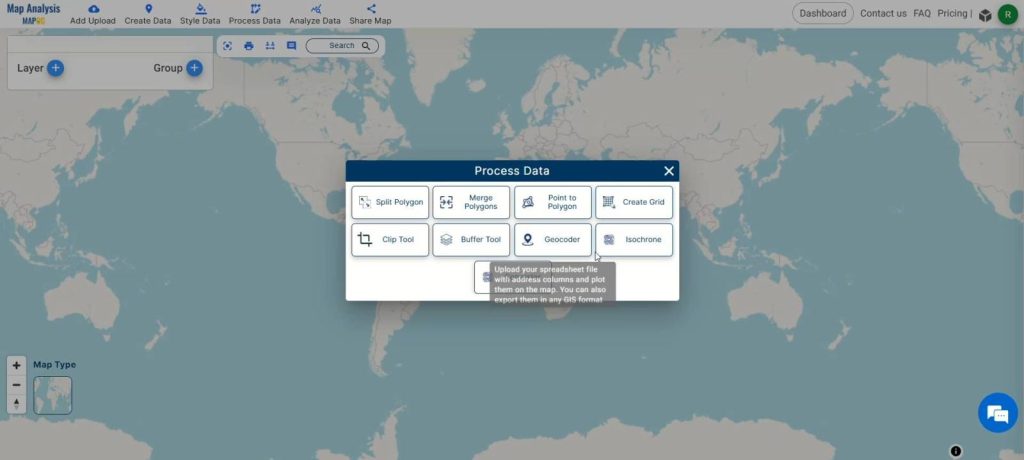
Open the MAPOG map analysis tool and navigate to “Process Data.” Select the “Geocoder” tool to initiate the geocoding process.
Step 2: Upload Address Data:
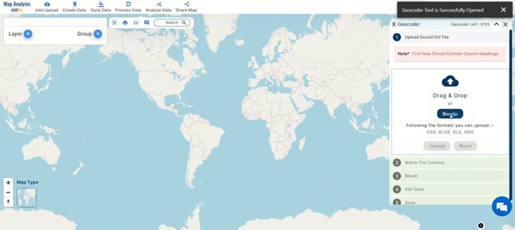
Upload your CSV or Excel file containing addresses or place names that you want to convert into geographic coordinates.
Step 3: Specify Attributes:
Specify the attributes such as Full Address or relevant attributes like Street, City, Zip Code, and State for accurate geocoding. Select the country of origin for your dataset to ensure precise conversion.
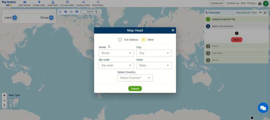
Once attributes are specified, click on “Submit” to start the geocoding process. MAPOG will process the data and convert the addresses into geographic coordinates.
Step 4: Adjust Layer Style:
After geocoding is complete, adjust the layer style by clicking on the action menu and selecting “Edit Style.” Choose the “Basic Style” option for a simplified visualization of the geocoded data.
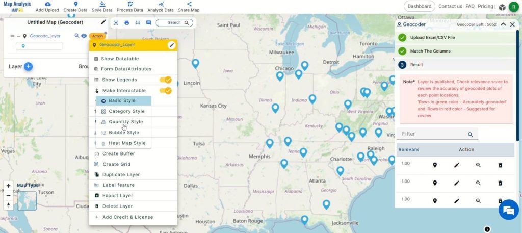
Step 5: Enabling Labeling for Geocoded Locations:
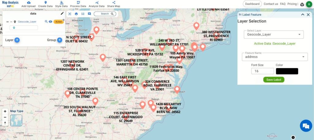
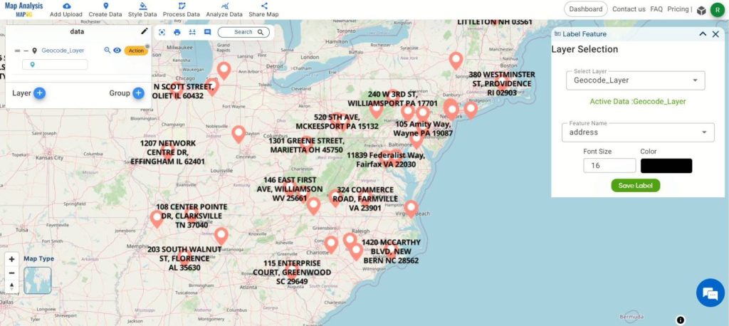
To ensure a user-friendly experience, enable labeling for geocoded locations using the “Label Feature” option in the action button of the geocoded layer.
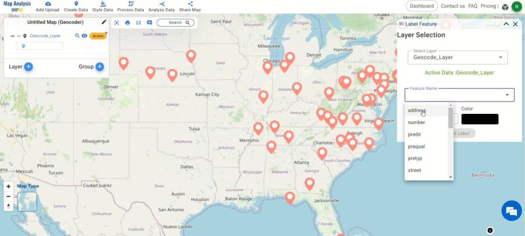
Step 6: Finalize and Save:
Click on the pencil icon to rename the map if desired. Then, click “Save Map” to apply the changes and keep your data organized.
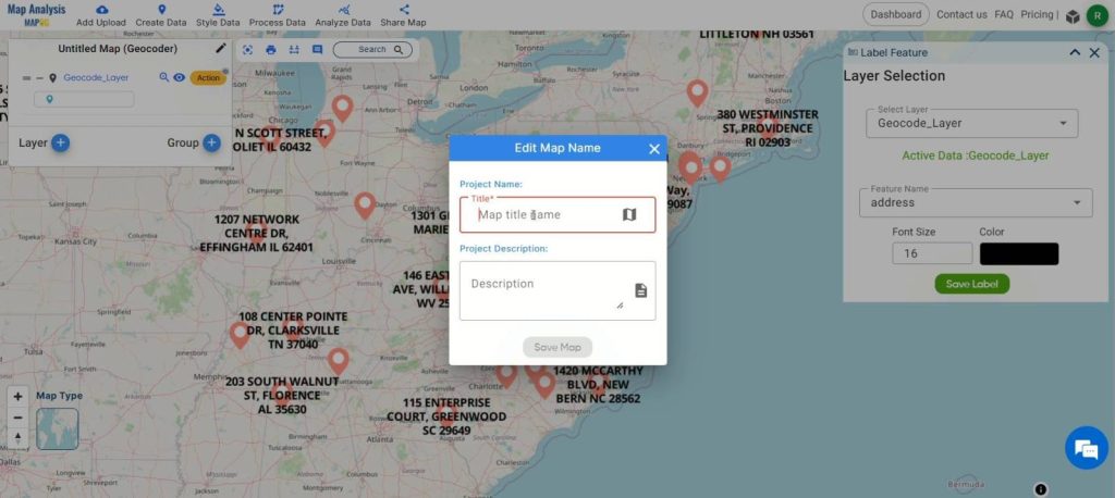
Step 7: Export Geocoded Data:
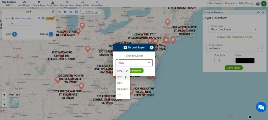
Export the geocoded data in your preferred format by clicking on the action button and selecting “Export Layer.” Choose from various formats such as Shp, Excel, GeoJSON, or Shapefile for further analysis or visualization.
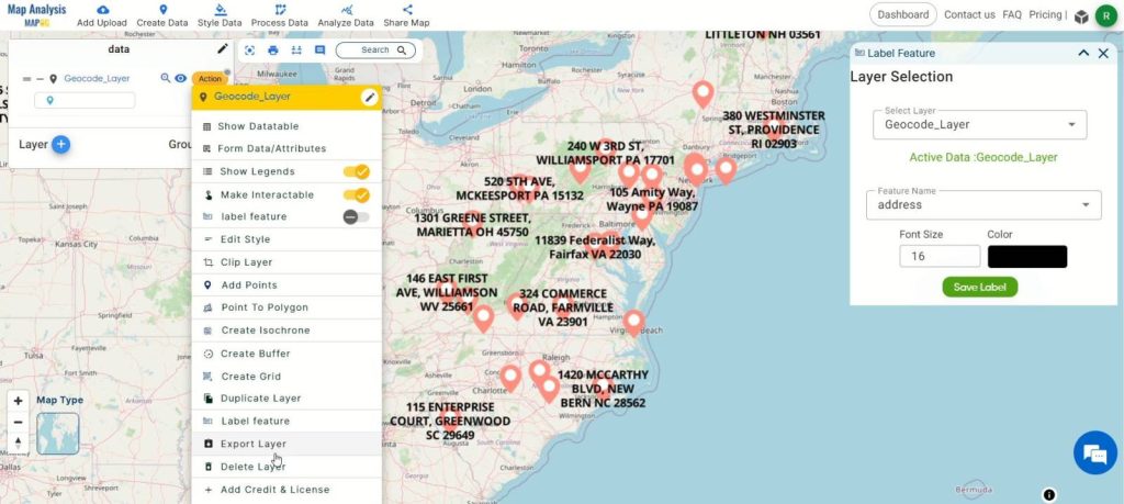
Major Findings:
Through geocoding with MAPOG, significant findings emerge. Firstly, there’s a notable enhancement in spatial accuracy as addresses or place names are transformed into precise geographic coordinates, fostering more accurate spatial analysis and visualization. This process streamlines data management, improves efficiency, and facilitates informed decision-making across various domains, including urban planning, business analysis, and emergency response. Geocoded data proves versatile, finding applications in market analysis, logistics planning, and disaster preparedness, while the user-friendly interface ensures accessibility to users of all levels. Overall, MAPOG‘s geocoding tool offers a cost-effective, quality-assured solution, empowering users to harness the power of spatial data for informed decision-making and collaboration.
Domains and Industries Benefiting
- Urban Planning
- Business and Marketing
- Emergency Services
- Logistics and Transportation
- Real Estate
- Environmental Management
- Healthcare
- Tourism and Hospitality
- Government and Public Services
- Research and Academia
Conclusion
In conclusion, geocoding with MAPOG stands as a pivotal solution for converting addresses or place names into geographic coordinates, facilitating precise spatial analysis and visualization. Its impact spans across a multitude of domains and industries, including urban planning, business, emergency services, logistics, real estate, environmental management, healthcare, tourism, government services, and academia. By providing dependable geocoded data, MAPOG enhances decision-making processes, augments efficiency, and encourages innovation across diverse sectors. With its intuitive interface and cost-effective approach, MAPOG empowers users to leverage spatial data for informed decision-making, collaboration, and societal advancement. For further inquiries or support, please reach out to us at support@mapog.com.
Other Articles
- Create a Map to find suitable sites for constructing a new house
- Create Map for Analyzing Water Quality using Heat Map Style
- Create Map – School Map Area Coverage Through Buffer Analysis
- Mapping Safety Create GIS Map : Game-Changing Approach to Hospital Risk Analysis
- Create Map for Real Estate Developer for Best Site Selection
- Create Map for Landfill Optimization: Spatial Analysis Approach
- Create Off-Road Hiking Routes: Using Bearing Angles and Distances
- Creating Safe Routes for Armies and Rescue Teams
- Mapping Tourist Spots Reachable Within an Hour with Isochrone Maps
- Analysis of Forest Fire and Map Risk Areas with Buffer Tool
- Mapping highway Buffer and Building Overlap Analysis – Extend Roads Width
- CREATING BUFFER MAPS TO IMPROVE THE SECURITY OF AIRPORTS AND OTHER INFRASTRUCTURES
- Digitalization of Road Networks by Drawing Line on Map