Welcome to the intersection of advanced technology and crime analysis. In this exploration, we delve into the dynamic realm of crime mapping using MAPOG, a powerful Geographic Information System (GIS) platform. Titled “Analyzing Crime Data: Unveiling Patterns and Trends Using MAPOG Map Analysis Tool,” our journey aims to decode intricate crime patterns, transforming raw data into actionable insights for informed decision-making. Join us as we navigate through the details, leveraging MAPOG to unravel the hidden narratives within crime data and chart a course towards creating safer communities.
Key Concept
In the landscape of modern crime analysis, the key concept revolves around leveraging MAPOG‘s advanced technology to unravel intricate patterns and trends in crime data. This exploration focuses on the synergy between cutting-edge Geographic Information System (GIS) technology and real-world challenges, emphasizing the strategic mapping and analysis of crime data in a given area. Our objective is to transform raw data into actionable insights, fostering informed decision-making for the creation of safer and more secure communities. In addition to this core mission, we leverage our expertise to address various other use cases through our buffer tool, ensuring a comprehensive approach to data-driven solutions.
Crime Mapping
Crime mapping is a technique that involves the visualization and analysis of crime data to identify patterns, trends, and hotspots in a geographical area. It leverages Geographic Information System (GIS) technology to map and display crime incidents spatially, providing law enforcement agencies, policymakers, and researchers with valuable insights into the spatial distribution of criminal activities.
Key aspects of crime mapping include:
- Data Collection: Gathering comprehensive crime data is the first step. This data typically includes information such as the type of crime, time of occurrence, and location.
- Geospatial Analysis: Using GIS tools, crime data is mapped onto geographical coordinates. This allows for the identification of spatial patterns and correlations that may not be immediately apparent in tabular data.
- Hotspot Identification: Through spatial analysis, areas with higher concentrations of criminal activity, known as hotspots, can be pinpointed. This information is crucial for deploying resources effectively and implementing targeted intervention strategies.
- Temporal Analysis: Understanding when crimes are more likely to occur can aid in resource allocation and the development of proactive measures. Temporal analysis can reveal patterns related to specific times of day, days of the week, or seasons.
- Crime Trend Analysis: Over time, crime mapping enables the observation of trends and changes in criminal activity. This information is valuable for long-term strategic planning and policy development.
- Community Engagement: Crime maps can be shared with the public to increase awareness and foster community involvement in crime prevention efforts. This transparency promotes collaboration between law enforcement and the community.
- Predictive Policing: Some advanced crime mapping systems incorporate predictive analytics to forecast future crime hotspots based on historical data. This assists law enforcement in proactively allocating resources to potential trouble areas.
The use of crime mapping enhances the efficiency and effectiveness of law enforcement efforts, enabling a data-driven approach to crime prevention and community safety. It also facilitates evidence-based decision-making and strategic planning for public safety initiatives.
Steps for Crime Mapping with MAPOG
Step 1: Data Collection and Upload
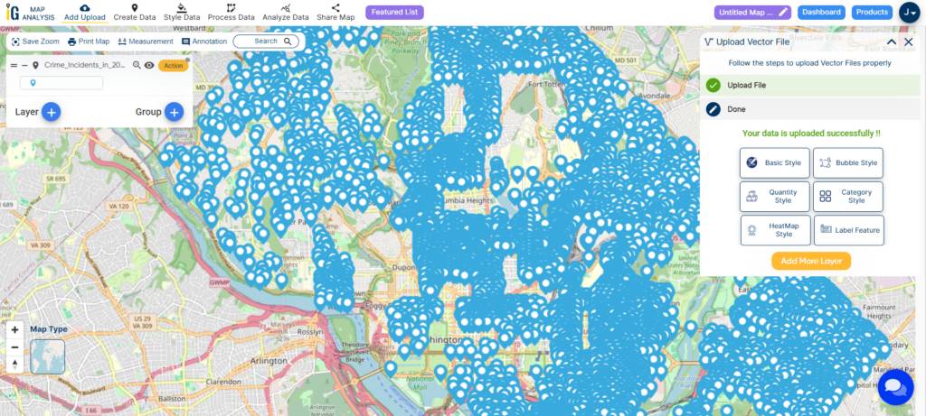
Begin by collecting crime data. Ensure that the data includes relevant attributes such as the type of crime, time, and location. Once the dataset is ready, use the “Upload Vector File” tool in MAPOG to import the crime data into the platform.
Step 2: Data Categorization and Styling
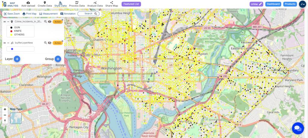
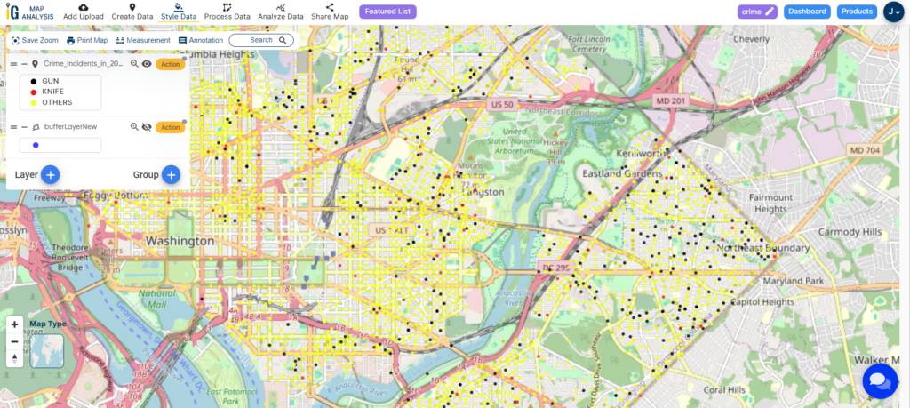
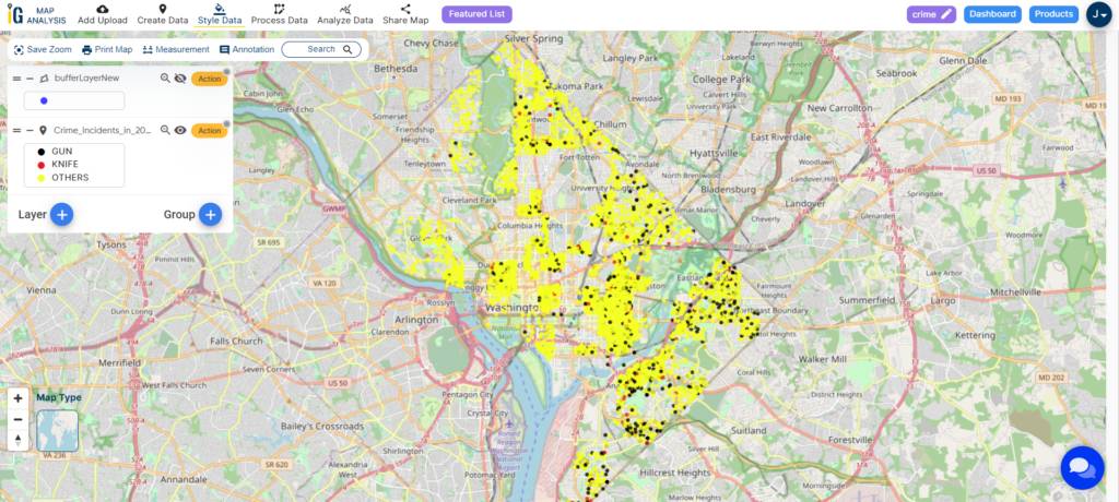
After uploading the data, navigate to the “Edit Style” button in the Action options. Here, select the “Category Style” to categorize the crime data based on attributes such as gun crime, knife crime, and other types. Assign distinct colours to each category to visually distinguish between different crime types on the map.
Step 3: Creating Buffers for Analysis
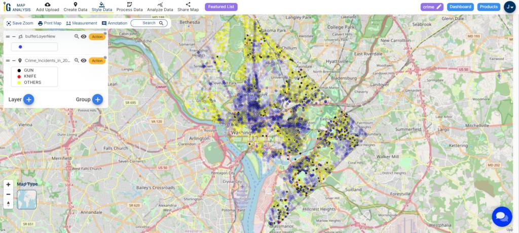
To enhance the study, create buffers around specific areas of interest. Click on the Action button near the layer and select “Create Buffer.” Choose the buffer distance, such as 100 meters or 500 meters, based on the study requirements and the reasons for analysis. This step helps in studying the spatial impact of crime incidents within specified distances.
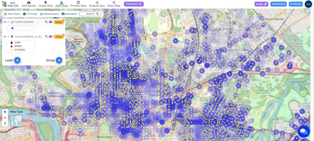
By following these three steps, you’ll have efficiently loaded, categorized, and enhanced your crime data within MAPOG. The categorized and buffered data provides a visually intuitive and analytically rich representation, allowing for a more in-depth exploration of crime patterns and their spatial relationships in.
Major Findings
Crime mapping has unveiled hotspots and spatial patterns, showcasing concentrations of gun, knife, and other crimes. This insight empowers law enforcement to strategically allocate resources, understand temporal trends, and engage the community by promoting awareness. The categorized data provides a clear visual representation, aiding in targeted interventions and fostering collaborative crime prevention efforts.
Domain and Industry
- Law Enforcement
- Public Safety Services
- Urban Planning
- Research and Academia
- Technology and Software Development
Conclusion
In conclusion, the integration of MAPOG into the crime mapping and buffer analysis processes has proven to be a pivotal factor in enhancing public safety. The visual insights gained from crime mapping, facilitated by MAPOG, including hotspot identification and spatial patterns, empower law enforcement to make informed decisions and deploy resources strategically. The use of MAPOG’s features for categorizing and styling crime data adds a dynamic layer to the analysis, providing clear visual representations that aid in targeted interventions and foster collaborative crime prevention efforts.
For further inquiries or assistance, please contact us at support@mapog.com. Together, let’s continue shaping safer communities through innovative technologies and data-driven strategies.
Other Articles
- Protecting Wetlands: Guide to Create GIS Map for Nature
- GIS Analysis in Urban Planning: Reshaping Transportation Future Insights of state/city
- Fast Emergency Response: Using GIS and Isochrone Maps for 10-Minute Ambulance Arrival
- Mapping Tiger Attack Hotspots – Create an Online Map and Share
- Make Routes for Military Aerial Planning- Through Bearing angle and Distance calculation – Online Route Compass
- Mapping Healthcare Efficiency: GIS Buffer Analysis of Hospital Locations
- Add WMS- Two step online view of WMS layer on a map
- Plot ATM locations on a map and embed on your website
- Map habitat locations of endangered animals & keep track of their living.