GIS optimizes supply chains and logistics by enabling precise route planning, fleet tracking, warehouse Site Selection, Demand Forecasting, and Risk Assessment. It enhances inventory management, facilitating warehouse location selection, reduces transportation costs, improves delivery efficiency, and supports data-driven decision-making, ensuring streamlined operations, better resource utilisation, and improved customer satisfaction across supply networks.
Key Concept in facilitating warehouse location selection for supply optimization
A key concept in facilitating warehouse location selection for supply optimization is geospatial analysis. It evaluates transportation networks, customer demand, supplier proximity, infrastructure, and costs. GIS tools analyze site accessibility, market reach, and risk factors, ensuring strategic placement that minimizes costs, reduces transit times, and enhances overall supply chain efficiency.
Use of GIS in facilitating warehouse location selection
- GIS is facilitating warehouse location selection by analyzing transportation networks, customer demand, supplier proximity, and infrastructure.
- GIS optimizes supply chains accessibility, minimizes costs, reduces transit times, and enhances supply chain efficiency.
- GIS tools assess geographic risks, labor availability, and market reach, ensuring strategic warehouse placement for improved logistics and distribution.
Creating a facilitating warehouse location selection for supply optimization:
1. Select Your Information from MAPOG
- Start by compiling all required information from the MAPOG website.
- This could involve the State Boundary file and the locations of the Industrial areas.
- Additionally, you can utilize pre-existing data sources or the information on the MAPOG website itself .
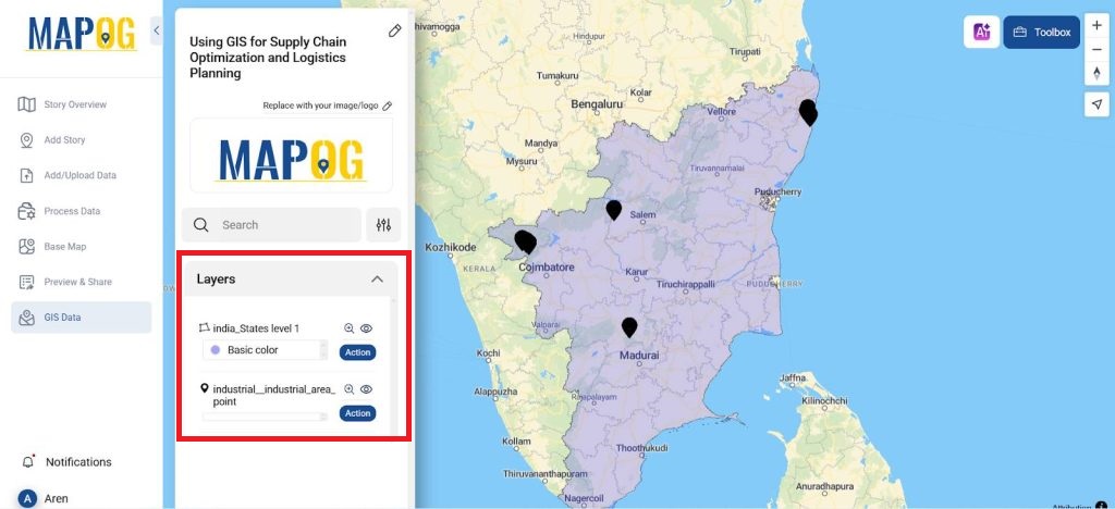
2. Upload Your Information
- For improved mapping, upload the state border file from GIS data >> Select the country >> Select the state >> Boundary layer to the map and change its opacity in style layer.
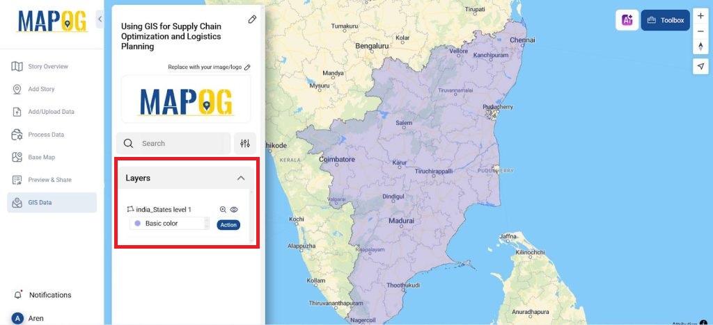
- Upload the industrial area so that we could plan for a warehouse to be located in the vicinity. By selecting the GIS data >> Select the country >> Select the state >> Industrial area.
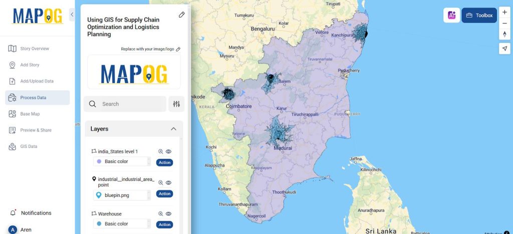
- The map now includes the industrial area point file.
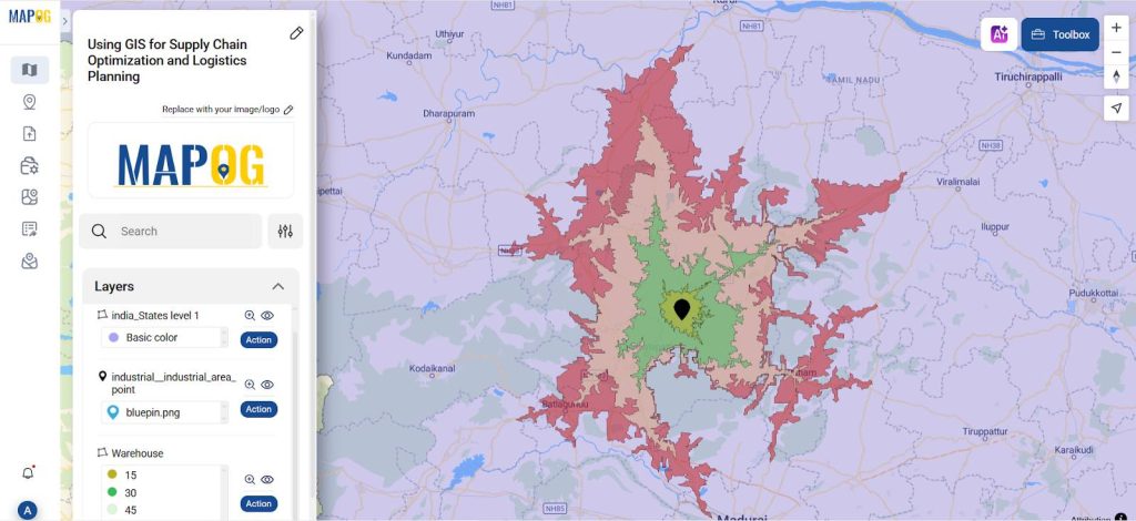
What is an isochrone tool?
The Isochrone tool in GIS maps areas reachable within a given time or distance from a point, aiding route planning, accessibility analysis, emergency response, and optimizing logistics, transportation, and service coverage.
3. ISOCHRONE TOOL
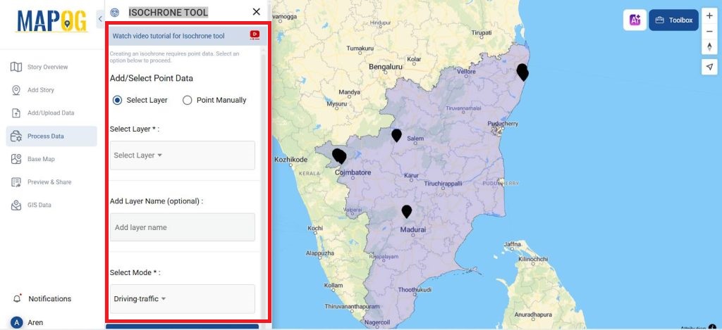
- In the process data select the isochrone tool to find a nearby location for a warehouse for all the 5 industrial sites.
- In add data select the select by layer and then select the layer in which we have create the isochrone tool.
- In mode select the driving mode- traffic as some locations lie in cites and the during limit to be 15 min, 30 min, 45 min and 60 mins.
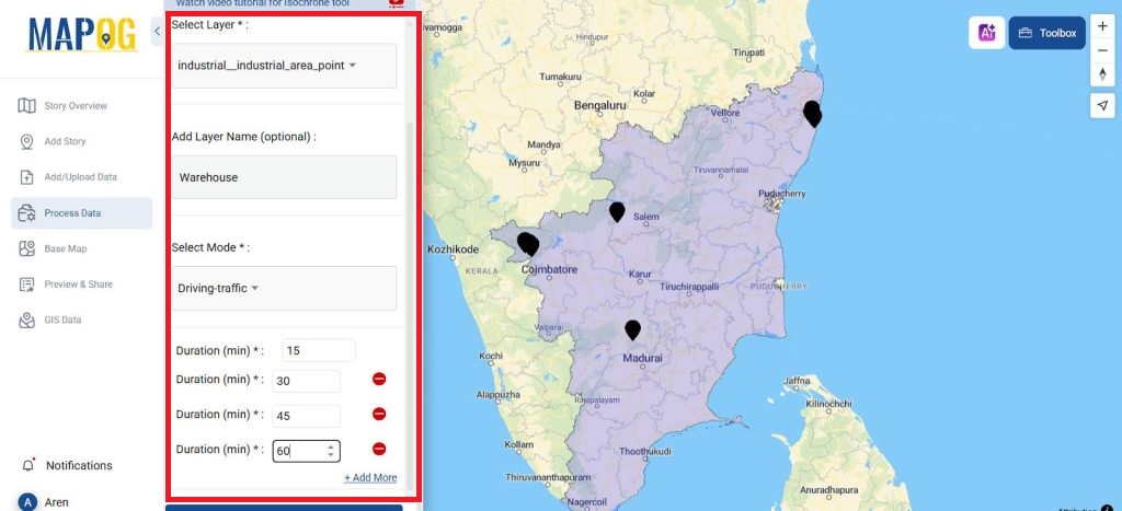
- From which we can plan a warehouse according to a travel limit and the availability of the locations.
4. Style Layer
- The isochrone layers that are produced for different lengths of time are styled to correspond to distinct categories from the action that chooses the style layer.
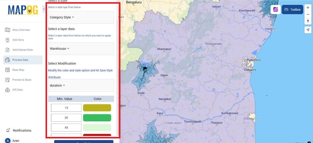
- In style select the category style and the layer data as Warehouse and the attribute to which it should be classified as duration.
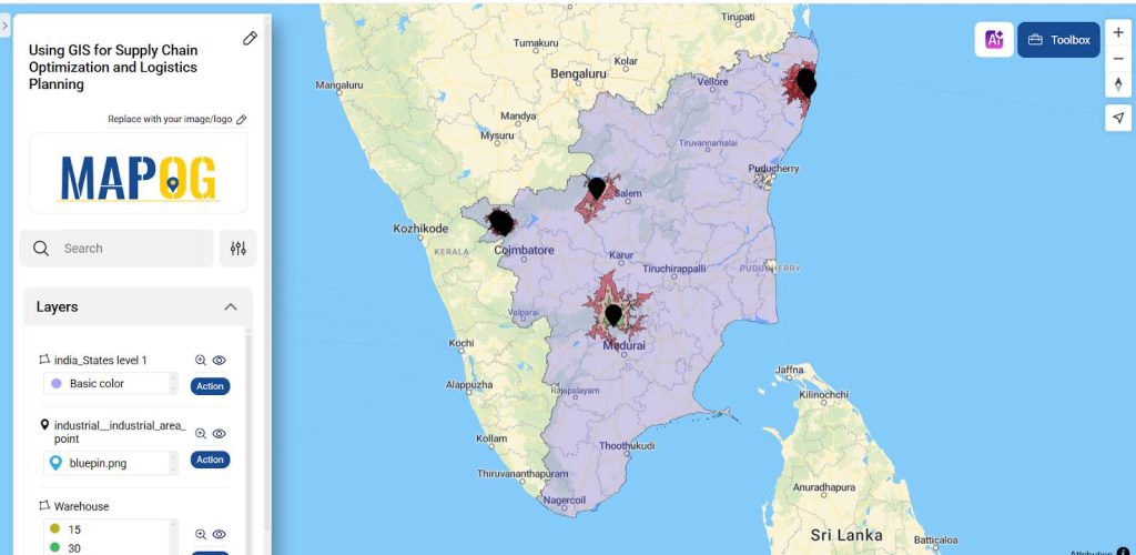
5. Analyze and Disseminate
Once your map is constructed, examine the visualization. By combining these elements, GIS enhances the choice of warehouse location by lowering transportation times, optimizing expenses, improving logistics effectiveness, and facilitating data-driven decision-making for a more efficient and successful supply chain.
Principal Results in Site Selection:
GIS optimizes site selection by analyzing transportation networks, market demand, supplier proximity, land suitability, risks, labor availability, and competitor locations. It ensures strategic placement, minimizing costs, improving logistics efficiency, reducing transit times, and enhancing decision-making for streamlined supply chain operations and improved overall performance.
Industry and Domain:
- GIS optimizes supply chains is essential in urban planning, retail, manufacturing, renewable energy, healthcare, transportation, agriculture, mining, real estate, logistics, tourism, defense, and environmental conservation.
- It helps identify optimal locations for businesses, infrastructure, and sustainability projects, improving efficiency, profitability, and decision-making based on spatial analysis and suitability modeling.
GIS data Used
Conclusion
GIS-based site selection enhances decision-making by analyzing spatial data, optimizing locations for various industries. And improving efficiency, sustainability, and profitability through data-driven, accurate, and objective site suitability analysis.
An open-source online map-making tool
A flexible, open-source program called MAPOG was created to make it simple for users to build interactive maps. Particularly for site selection, logistic planning and supply optimization. GIS enables data-driven site selection by analyzing spatial criteria, applying suitability models, and optimizing locations for urban planning, business, and infrastructure. Many of the articles listed below were created with MAPOG.
- How to Use Convex Hull for Contagious Disease Mapping & Outbreak Control
- Isochrone Analysis in GIS: Optimize Travel Times for Faster Delivery & Urban Planning
- How to Geocode Excel Data and Create an Interactive Map (Step-by-Step Guide)
- Creating Point Data for Urban Planning: Digitizing Settlement Features & Infrastructure Mapping
Final thoughts
MAPOG is a simple tool for creating site location analyses, making it accessible to people, companies, and educators. Who wish to share knowledge about logistics planning and supply chain optimization. Have you ever tried utilizing a GIS to find a site? If you had any experience, how was it? It’s an excellent way to engage your audience and analyze data visually