In the heart of urban development, where cityscapes and transportation networks intersect, the transformative influence of GIS analysis in urban planning takes center stage. This article delves into the intricacies of reshaping the transportation future through the lens of MAPOG GIS tool, unraveling critical insights that hold the potential to redefine the landscape of [State/City].
Key Concept: Our mission is clear: to enhance the synergy between buses, trains, and settlements across city/state. MAPOG serves as our guide, helping create a dynamic map that illuminates the locations of bus stops and train stations, ultimately ensuring convenient access for residents of settlements.
MAPOG GIS Analysis in Urban Planning
Following are the steps for enhancing urban transportation networks through MAPOG Spatial Analysis:
- We start our journey by adding the essential data using MAPOG’s For this click on Add Upload button from top left and select Add GIS Data.
- Now search for the desired data. I am using United States Arizona Gis data.
- From bus stops and train stations to roads and settlements, each piece of information is carefully integrated. With data in place, the next step is to make the map visually appealing. We customize the appearance of bus stops and train stations using MAPOG’s styling options. A simple click, choose a style that stands out, and repeat the process for train station.
- Edit the untitled Map : Edit the untitled map to ‘Urban Transportation Network Map.’
- You can also edit the layer name also with click on Action Button.
- Click on Style Data, a pop up appear and choose desired style.
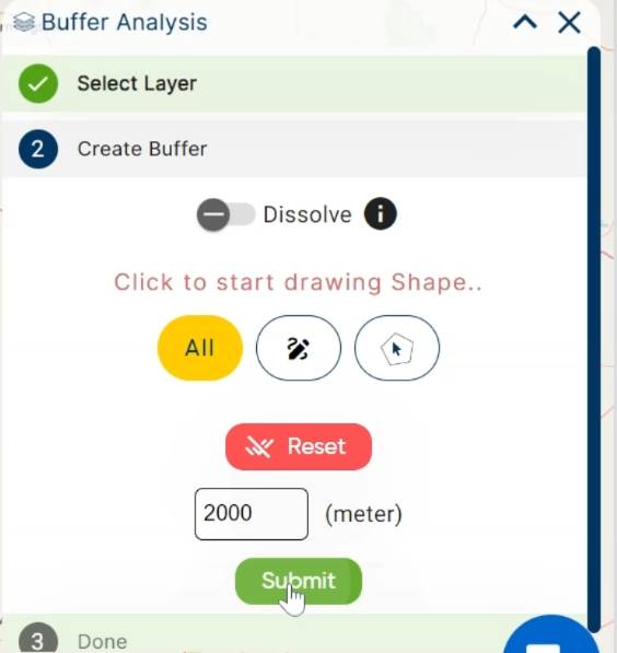
Buffer Zone: Go to Process Data and tap on BufferTool. Unveiling the influence of settlements, we create magic circles (buffers) around them using MAPOG. These buffers, set at 2000 meters, illuminate the areas touched by settlement impact. Select settlement data, apply the buffer tool, and set the distance to 2000 meters for a clearer view.
- Select settlement data, apply the buffer tool, and set the distance to 2000 meters for a clearer view.

Proximity Analysis: Armed with MAPOG’s proximity analysis tool, we play detective to find the closest bus stops and train stations for each settlement.
Finish and Export:
Wrapping up our journey, we finalize the map, ensuring every insight gained is captured. The “Export” option in MAPOG becomes our last step, saving and sharing the optimized transportation map with the world.
Finalize your work, choose export options, and save the optimized transportation map.
Major Findings:
- Discover how settlements influence transportation areas.
- Identify the nearest bus stops and train stations for settlement residents.
- Understand the crucial role of roads in connecting the transportation network.
Domain and Industry:
Our expedition falls within the domains of Transportation and Urban Planning, utilizing MAPOG as our technological compass. This innovative approach integrates Geographic Information Systems (GIS) and spatial analysis to optimize the transportation network, aligning with the unique characteristics of Arizona.
Conclusion of Mapog Gis Analysis in Urban Planning
As our Arizona transportation odyssey comes to an end, the result is a meticulously crafted map that goes beyond aesthetics. It represents a significant step towards a more efficient and accessible public transportation system. By improving connections and understanding spatial relationships, our journey with MAPOG contributes to a better, more connected Arizona.
You can also try other tool like Route Compass use in military aerial route planning or download data for anaylsis from MAPOG GIS Data.
Other Articles
- Protecting Wetlands: Guide to Create GIS Map for Nature
- GIS Analysis in Urban Planning: Reshaping Transportation Future Insights of state/city
- Fast Emergency Response: Using GIS and Isochrone Maps for 10-Minute Ambulance Arrival
- Mapping Tiger Attack Hotspots – Create an Online Map and Share
- Make Routes for Military Aerial Planning- Through Bearing angle and Distance calculation – Online Route Compass
- Mapping Healthcare Efficiency: GIS Buffer Analysis of Hospital Locations
- Add WMS- Two step online view of WMS layer on a map
- Plot ATM locations on a map and embed on your website
- Map habitat locations of endangered animals & keep track of their living
- Create Map on Literacy Rate
- Create Map – DIGITIZING SOLAR, HYDROELECTRIC, WIND AND BIOMASS POWER PLANTS – RENEWABLE ENERGY
- Create a Map to find suitable sites for constructing a new house
- Create Map for Analyzing Water Quality using Heat Map Style
- Create Map – School Map Area Coverage Through Buffer Analysis
- Mapping Safety Create GIS Map : Game-Changing Approach to Hospital Risk Analysis
- Create Map for Real Estate Developer for Best Site Selection
- Create Map for Landfill Optimization: Spatial Analysis Approach
- Create Off-Road Hiking Routes: Using Bearing Angles and Distances
- Creating Safe Routes for Armies and Rescue Teams
14 thoughts on “GIS Analysis in Urban Planning: Reshaping Transportation Future Insights of state/city”