What is Merge Polygon tool?
The Merge Polygon tool is a functionality that enables the combination or consolidation of adjacent or overlapping polygons into a single, cohesive polygonal feature. This tool is essential for spatial data processing and analysis, allowing users to simplify complex datasets, resolve geometric inconsistencies, and streamline data representation. This article delves into the significance of the Merge Polygon tool and its application in Protected Areas management using Merge Polygon tool in MAPOG.
The benefits of Merge Polygon tool include the following:
- Data simplification: By consolidating multiple polygons into a single feature, the tool reduces data complexity and improves data manageability.
- Improved analysis: Merging polygons eliminates overlaps and gaps, ensuring more accurate spatial analysis results.
- Enhanced visualisation: Merged polygons provide a clearer representation of spatial relationships and patterns, aiding decision-making and communication.
- Time and Resource Efficiency: This tool saves time and reduces manual effort.
The Merge Polygon tool is essential for various spatial analysis tasks, including administrative boundary management, land parcel integration, ecological analysis, and urban planning. By consolidating polygonal datasets, analysts can create comprehensive maps and conduct in-depth spatial analysis to support decision-making processes in diverse fields.
Key Concept
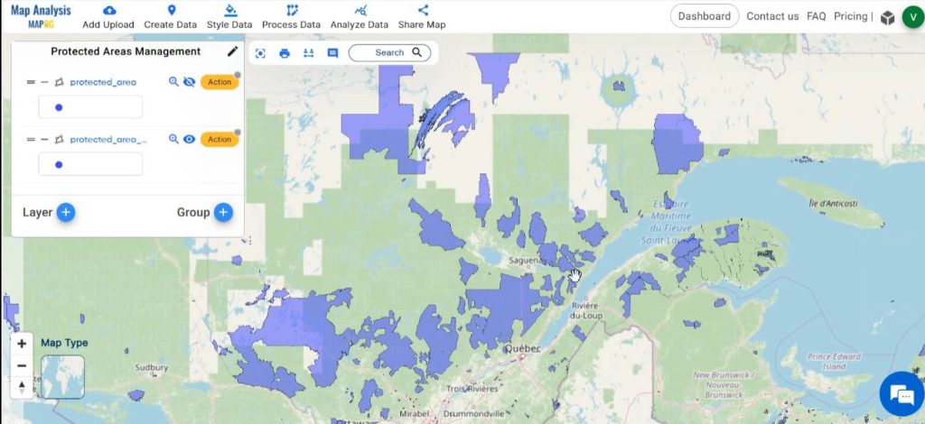
Within the context of protected areas management, Merge Polygon tool enables the consolidation of boundary delineation. By merging protected areas polygonal datasets, conservation practitioners can create holistic representations of protected areas, facilitating informed decision-making and resource allocation. Venture into other captivating articles featured on our blog using the merge polygon tool like How to Merge Polygons in Maps and articles using other tools such as Create a Map: Filter Camping Spots in a Region Within – Points in polygon, Crime Data Mapping: Finding Patterns and Trends Using GIS etc., inviting readers to explore beyond the familiar. The links for GIS Data which we are using here are mentioned at the end of the article.
Follow the below process Step-by-step for Protected Areas Management
Step 1: Open Map Analysis
Open Map analysis interface from MAPOG platform.
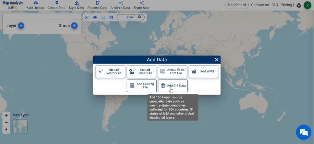
Step 2: Upload data
To add the required data, click on the Add Upload option from the menu bar at the upper left end, and then go to the Add GIS Data option.
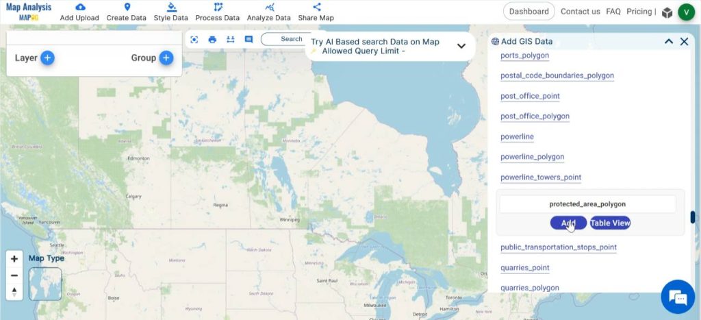
Begin by selecting your preferred country from the GIS data. Scroll down and Add protected areas polygon layer. With the Table view option preview the data table of the chosen layer.
Step 3: Save map
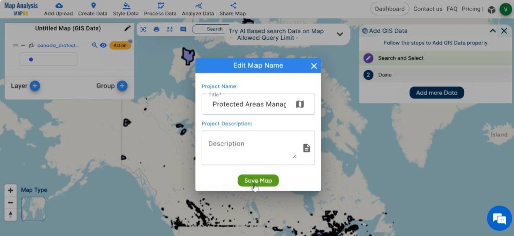
Save the map with an appropriate name, by clicking on the pencil icon near “Untitled Map”. Enter a suitable name, and if desired, provide a brief description of your project. Finally, save the map by clicking on the “Save Map” button.
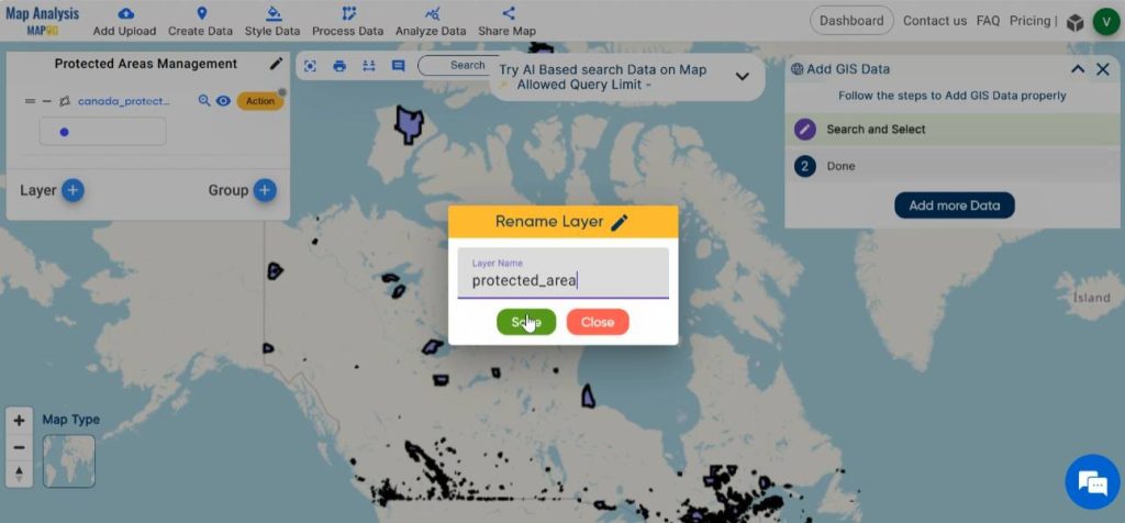
Step 4: Rename Layer
For easy understanding, rename the layer. For this click on Action and then select the pencil icon. Enter a suitable name. Finalise by clicking on save.
Step 5: Merge the Protected areas
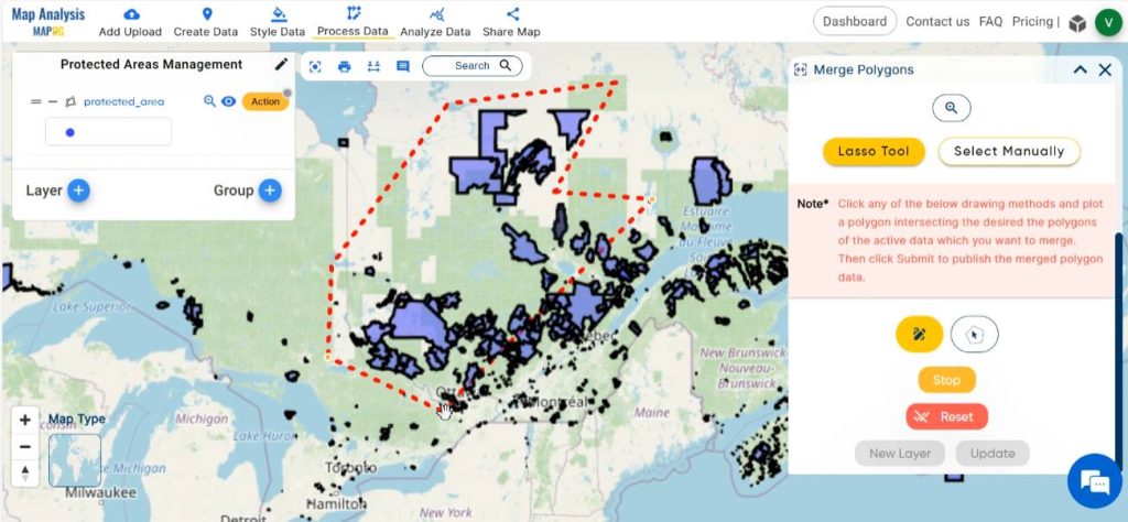
Now, we can converge the fragmented protected area into a single component for effective management of protected areas. In order to do this, click on Process Data, then select the Merge Polygon tool.
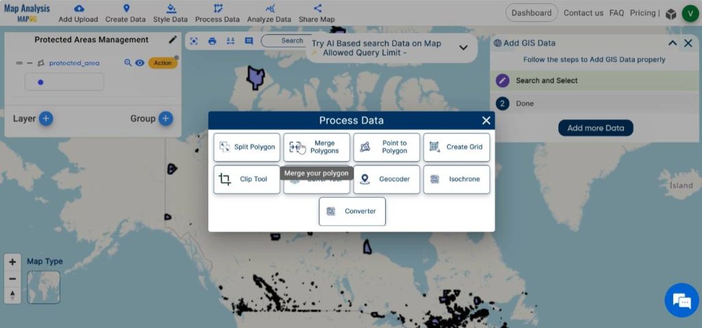
Select the protected area layer in the given tab.
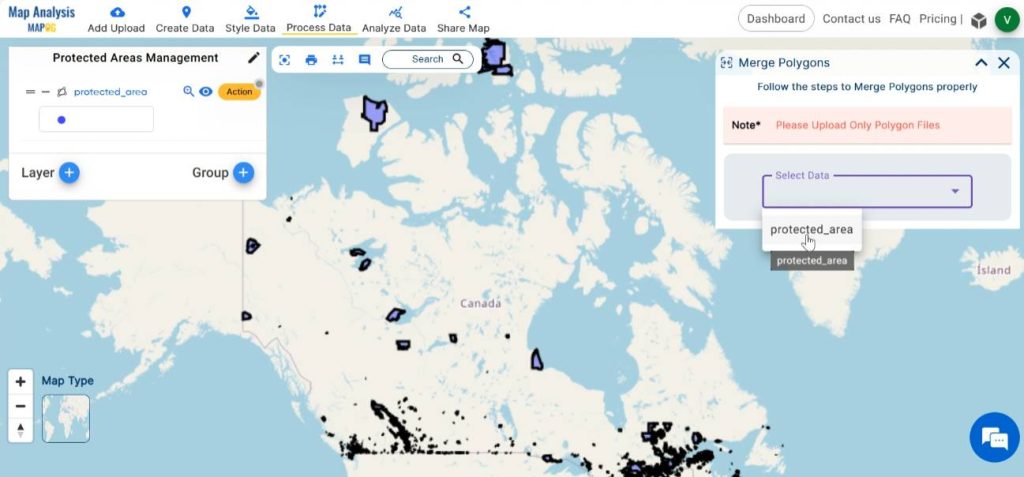
There are two methods for merging polygons: using the Lasso tool or manually selecting polygons.
1.Using Lasso tool
At first, select the lasso tool and then choose from various drawing methods given.
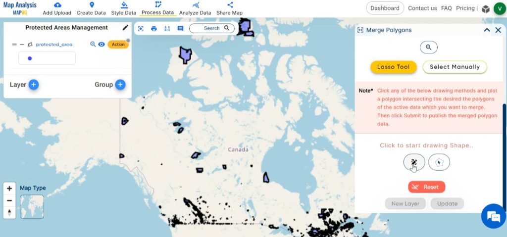
Next, delineate a polygon intersecting the desired areas on the map that require merging.
After drawing the polygon, there are two options to save the changes: either generate a new layer containing the merged polygons while retaining the original ones or directly update the existing data with the merged polygons.
2.Using Select Manually
Start by clicking on the “Select manually” option, then proceed to manually pick the polygons that wish to merge by performing left-clicks on the map.
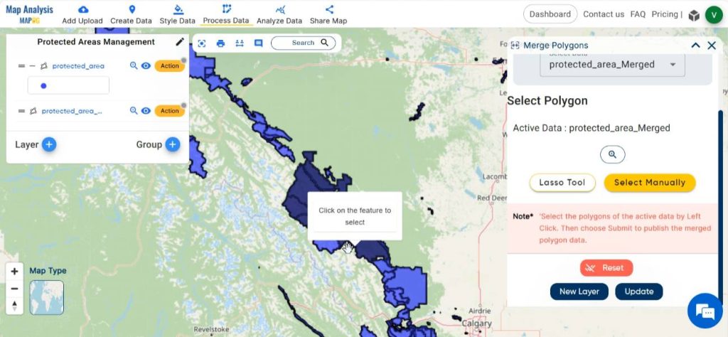
Following the selection process, users can either create a new layer incorporating the merged polygons or update the current layer with the merged data.
Ultimately, this process serves to enhance the merging of protected area boundaries, thereby facilitating more informed decision-making for Protected Areas Management.

Major Findings
- Spatial consolidation: The map illustrates the spatial consolidation of adjacent polygons within the protected area, facilitating more effective management strategies.
- Management priorities: The map helps identify management priorities within the protected area requiring increased enforcement.
Industry and Domain
- Conservation organisations: These maps aid in effectively managing and monitoring protected areas.
- Government agencies: Government agencies can utilise these maps to make informed decisions about land use planning and natural resource management.
- Researchers and scientists: This map helps them in studies aimed at understanding ecosystem dynamics and biodiversity patterns.
Conclusion
The Merge Polygon tool in MAPOG offers a potent solution for enhancing spatial data integration and analysis in protected areas management. By harnessing this tool effectively, conservation practitioners can gain deeper insights into ecosystem threats, and conservation priorities, thereby fostering more informed and proactive management strategies.
GIS Data Links
Explore more content on our blog:
Protecting Wetlands: Guide to Create GIS Map for Nature
GIS Analysis in Urban Planning: Reshaping Transportation Future Insights of state/city
Fast Emergency Response: Using GIS and Isochrone Maps for 10-Minute Ambulance Arrival