Explore the intersection of cutting-edge technology and environmental responsibility in civil engineering. This article focuses on Environmental Impact Assessments (EIAs), emphasizing the role of the MAPOG Route Compass in precise spatial analysis. Discover how this innovative tool revolutionizes decision-making, shaping a future of conscientious engineering practices.
Now we are on Google Play store also. Below is the link for download.

Route Compass Mobile App for calculating distance and bearing angle.
Key Concept
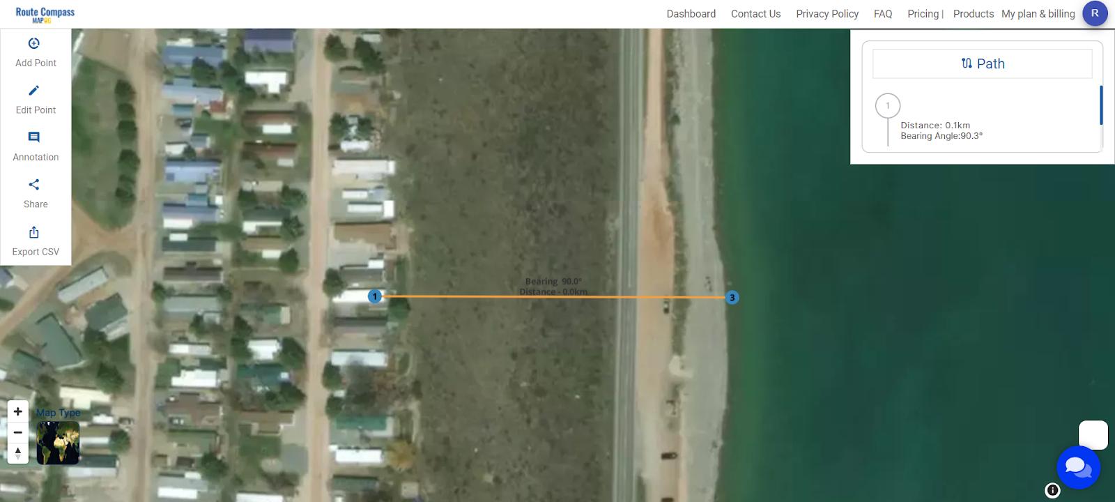
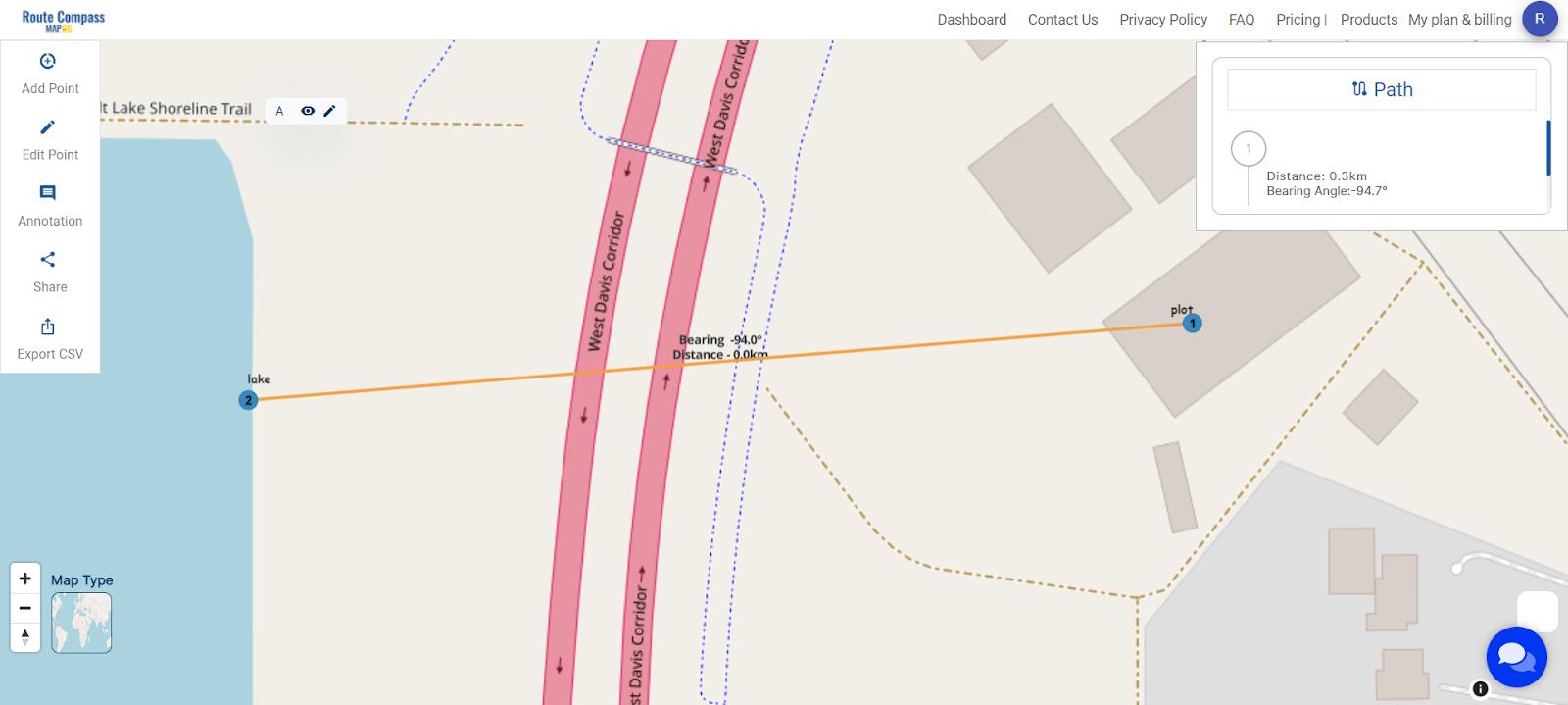
MAPOG Route Compass is vital for construction near lakes, ensuring legal compliance with precise distance measurements between the site and the water body, particularly in maintaining required setbacks.
Steps for Environmental Impact Assessment
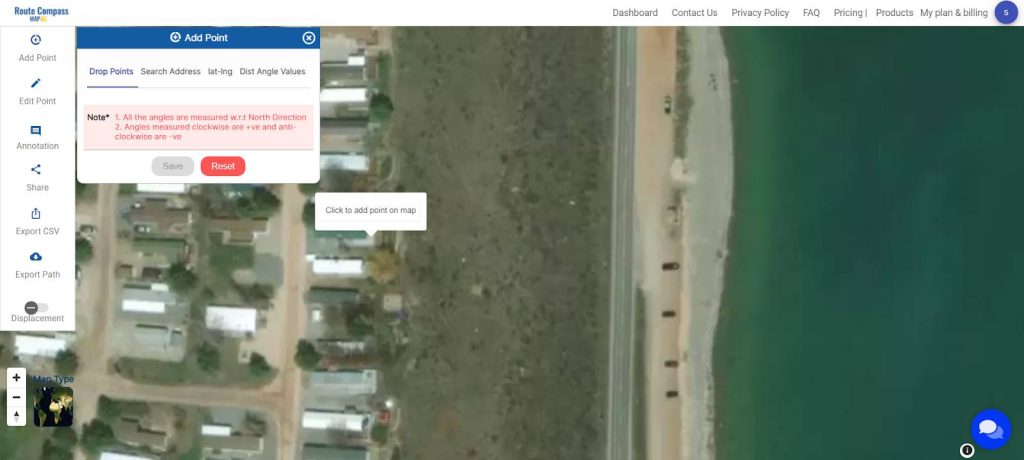
Step 1: Marking the Construction Site
- Click on “Add Point” to precisely designate the construction site.
Step 2: Identifying Nearby Water Body
- Utilize the “Add Point” function again to mark a point on the nearby lake or water body, establishing the basis for distance calculations.

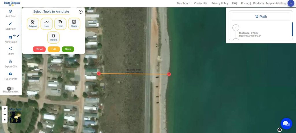
Step 3: Labeling Points for Clarity
- Click on “Annotation,” choose “Text,” and save to label the points accurately, ensuring clear identification during spatial analysis.
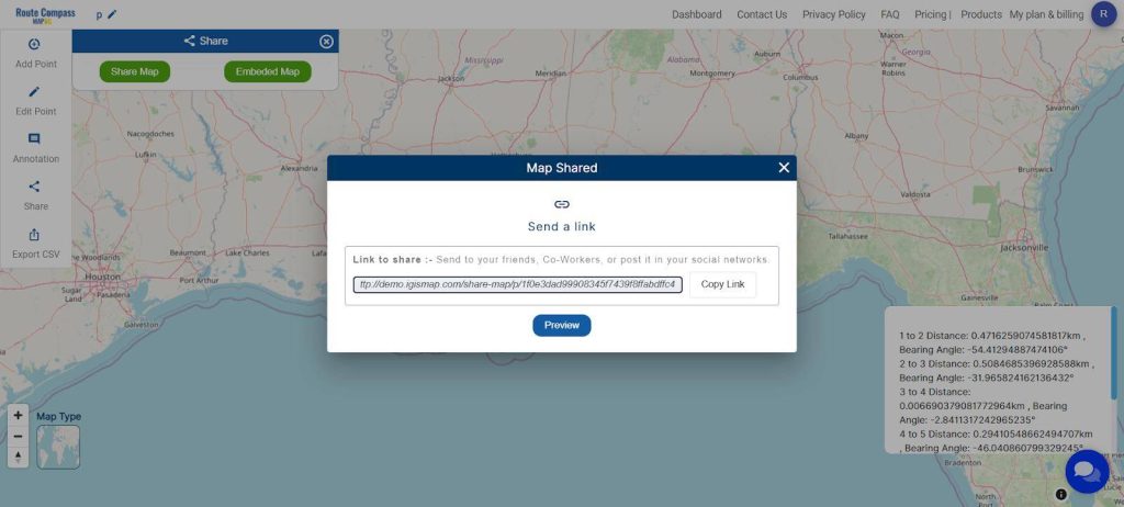
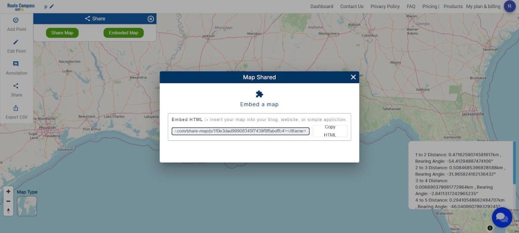
Step 5: Sharing and Embedding Options
Facilitate collaboration by sharing your project. Use the ‘Share Map’ option to send it to friends or post it on social media. For embedding into a blog or website, opt for ‘Embed HTML’ for seamless integration.
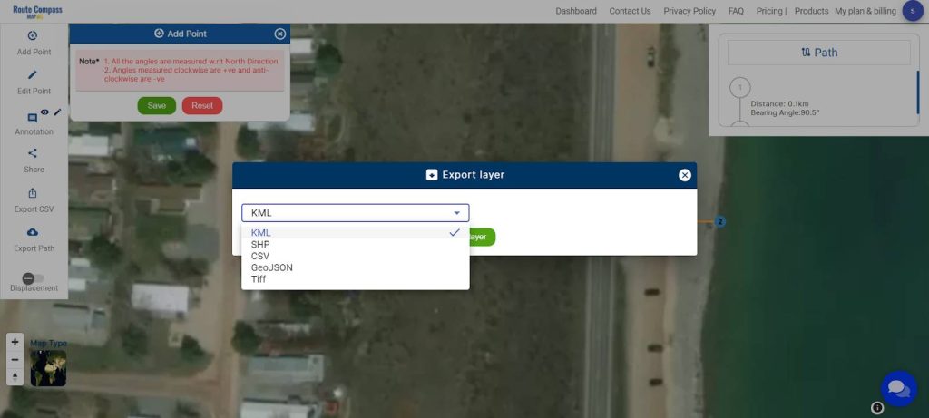
Step 4: Download Information in CSV Format or export path in other formats
For added convenience, MAPOG Route Compass allows the download of all information in a CSV file format. This feature ensures accessibility and easy sharing of project data. You can also use the export path tool for downloading the data.
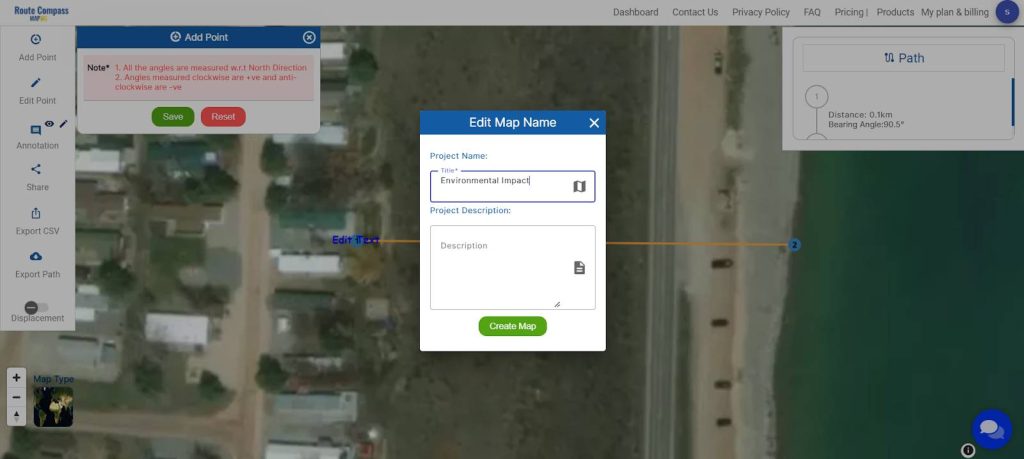
Step 6: Save and Rename Project
Save your project by clicking the pencil icon above, where you can also rename your project for better organization.
Major Findings
The utilization of the MAPOG Route Compass in conducting spatial analysis for environmental impact assessments in civil engineering has yielded precise and actionable insights. By employing this tool, the accurate measurement of distances between the construction site and nearby water bodies has significantly contributed to meticulous planning and adherence to legal and regulatory requirements. The spatial analysis facilitated by MAPOG has not only identified potential environmental impacts but has also empowered engineers to implement strategic mitigation measures effectively.
Importance of Using MAPOG Route Compass
The significance of employing the MAPOG Route Compass lies in its ability to provide reliable and precise distance measurements. This tool ensures that construction activities maintain required setbacks from sensitive environmental features, such as lakeshores, contributing to legal compliance and responsible engineering practices. The efficiency and accuracy of MAPOG enhance the overall quality of Environmental Impact Assessments, enabling engineers to make informed decisions and minimize the ecological footprint of construction projects.
Importance of Using MAPOG Route Compass: The significance of employing the MAPOG Route Compass lies in its ability to provide reliable and precise distance measurements. This tool ensures that construction activities maintain required setbacks from sensitive environmental features, such as lakeshores, contributing to legal compliance and responsible engineering practices. The efficiency and accuracy of MAPOG enhance the overall quality of Environmental Impact Assessments, enabling engineers to make informed decisions and minimize the ecological footprint of construction projects.
Domains and Industries Benefiting
- Civil Engineering and Construction
- Environmental Consulting
- Regulatory Compliance
- Real Estate Development
- Government and Urban Planning
- Academic and Research Institutions
- Public Awareness and Advocacy
- Technology Development
Conclusion
In conclusion, the integration of the MAPOG Route Compass in environmental impact assessments within civil engineering has proven instrumental in fostering environmental stewardship. The tool’s capacity for precise spatial analysis has empowered professionals to navigate the complex landscape of construction planning near lakes, ensuring a delicate balance between developmental progress and ecological preservation. As a result, MAPOG emerges not only as a compass for spatial navigation but as a guiding force in promoting sustainability and responsible engineering practices in the construction industry.
For further inquiries or assistance, please reach out to us at support@mapog.com. MAPOG not only serves as a compass for spatial navigation but stands as a guiding force in promoting sustainability and responsible engineering practices in the construction industry.
Other Articles
- Protecting Wetlands: Guide to Create GIS Map for Nature
- GIS Analysis in Urban Planning: Reshaping Transportation Future Insights of state/city
- Fast Emergency Response: Using GIS and Isochrone Maps for 10-Minute Ambulance Arrival
- Mapping Tiger Attack Hotspots – Create an Online Map and Share
- Make Routes for Military Aerial Planning- Through Bearing angle and Distance calculation – Online Route Compass
- Mapping Healthcare Efficiency: GIS Buffer Analysis of Hospital Locations
- Add WMS- Two step online view of WMS layer on a map
- Plot ATM locations on a map and embed on your website
- Map habitat locations of endangered animals & keep track of their living