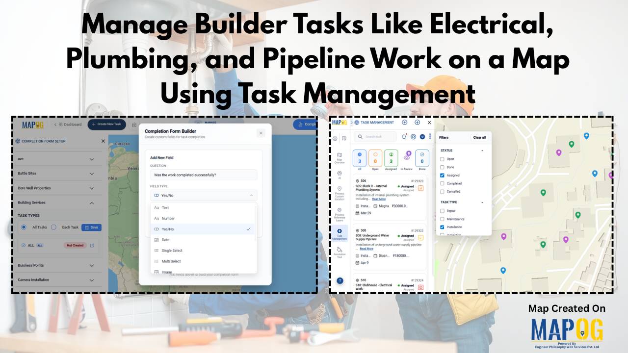
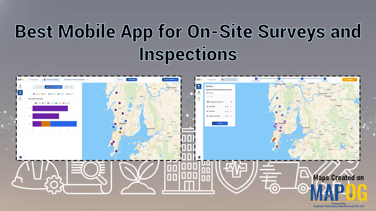
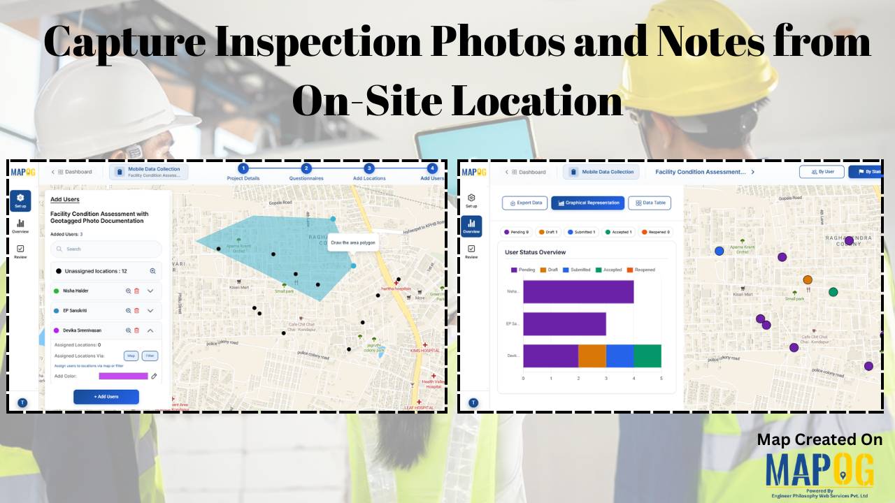
#DataVisualization

On-Map Travel Planning How to Build and Share Interactive Itineraries

On-Map Travel Planning: How to Build and Share Interactive Itineraries Transform Client Experiences

On-Map Travel Planning: How Interactive Itineraries Transform Client Experiences In modern travel , clients no longer want static itineraries—they want to see their journey unfold. Traditional PDFs and spreadsheets may list activities, but they fail to convey geography, movement, or the emotional arc of a trip. This is where on-map travel planning changes the game. … Read more

How to Map Crops Online: Step-by-Step Guide for Farmers, Planners, and Researchers

Mapping crops on a map platforms provides an effective way to categorize, analyze, and visualize agricultural data. By organizing crop information into clear layers, farmers, planners, and researchers can better understand agricultural trends and regional strengths. This method not only helps in identifying where each crop thrives but also supports long-term planning, monitoring, and sharing … Read more

How to Create Interactive Real Estate Portfolio Maps: Organize, Visualize, and Showcase Projects

In real estate development, success isn’t just built—it’s mapped. Today’s developers are moving beyond static brochures to embrace tools like interactive real estate portfolio map. Hence, these dynamic tools allow developers to present their projects with clarity, connectivity, and context. For example, just as agents use maps to help homebuyers understand surroundings, developers are now … Read more

electric aerial vehicle routes

How to Plan Efficient Electric Aerial Vehicle Routes Using Bearing Angle and Distance

Planning efficient electric aerial vehicle routes is, therefore, becoming essential in industries like logistics, disaster response, and surveillance. Not only does a precise route save time, but it also ensures flight safety and energy optimization. Consequently, MAPOG simplifies this process by combining bearing angle & distance calculations with real-world coordinates. In this article, we’ll explore … Read more

Mapping History with GIS: Turn Historical Events into Interactive Stories

Historical events have, over centuries, shaped civilisations and cultures. Consequently, mapping history with GIS tools provides new insights into how past events unfolded geographically. As a result, this promotes deeper engagement, improves retention, and simultaneously encourages an immersive way of exploring timelines and stories. Moreover, by integrating GIS tools with historical data, storytelling becomes more … Read more

GIS for Deforestation Tracking

How to Use GIS for Deforestation Tracking and Forest Loss Analysis

Using GIS for deforestation tracking has become a powerful approach in environmental research. Every year, massive tree cover disappears. Therefore, tracking these changes accurately becomes essential for timely forest conservation efforts. GIS helps researchers and conservationists visualize forest loss clearly and over time. Consequently, it enables faster and smarter decision-making. One of the simplest tools … Read more

Mapping Military Flight Paths

Mapping Military Flight Paths: How GIS Helps Calculate Distance and Bearing Angles

Mapping Military Flight Paths is a crucial component in modern aerial defense planning. With the continuous rise of geographic intelligence, GIS technology now plays a central role in not only plotting accurate coordinates but also in calculating distances and determining precise bearing angles. This process, therefore, goes far beyond simply drawing lines on a map—it … Read more

Create a Buffer Analysis to Locate Hospital Within 5km radius of Village

Finding healthcare gaps isn’t just about counting hospitals. Rather, it’s about understanding access, travel range, and unserved rural zones. Therefore, with the help of MAPOG, planners and health departments can visualize these relationships using buffer analysis. Additionally when used in combination with choropleth-style overlays, village point layers, or service area mapping tools, MAPOG makes it … Read more

How to Map and Manage a Franchise Business with Location and Service Filters

If you’re planning to expand your food chain or track multiple branches across cities, then learning how to map a franchise business with smart filters is a true breakthrough. By doing so, you can visualize store data on an interactive platform, which in turn helps you easily organize locations, services, and customer insights. Whether you’re … Read more

How to Map Rental Properties with Nearby Amenities Using Interactive GIS Maps

Whether you’re a real estate agent, property manager, or investor, mapping rental properties with key nearby amenities gives your listings the edge. In fact, visual maps offer clarity, transparency, and better decision-making for both renters and owners. By combining precise coordinates with contextual data—such as distance from schools, hospitals, or parks—you ultimately make the rental … Read more