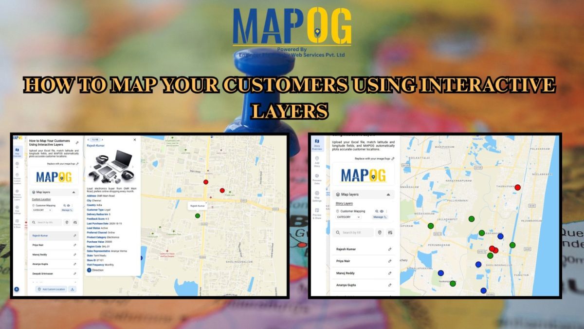
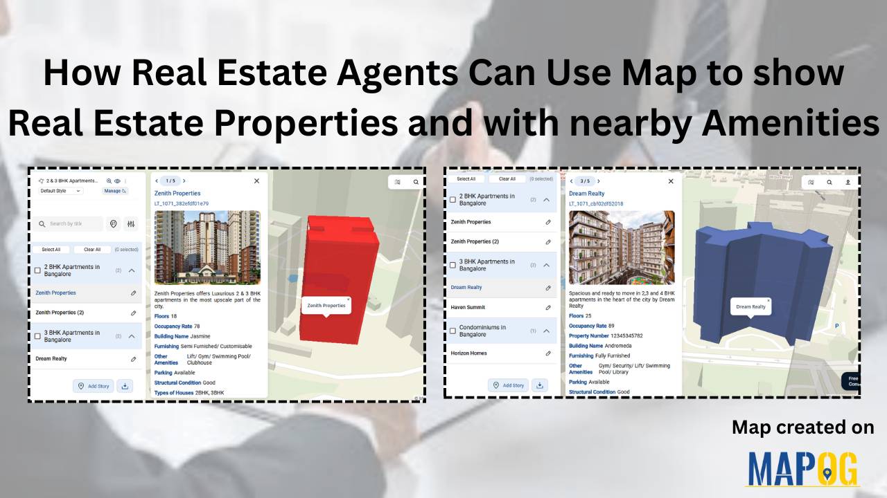
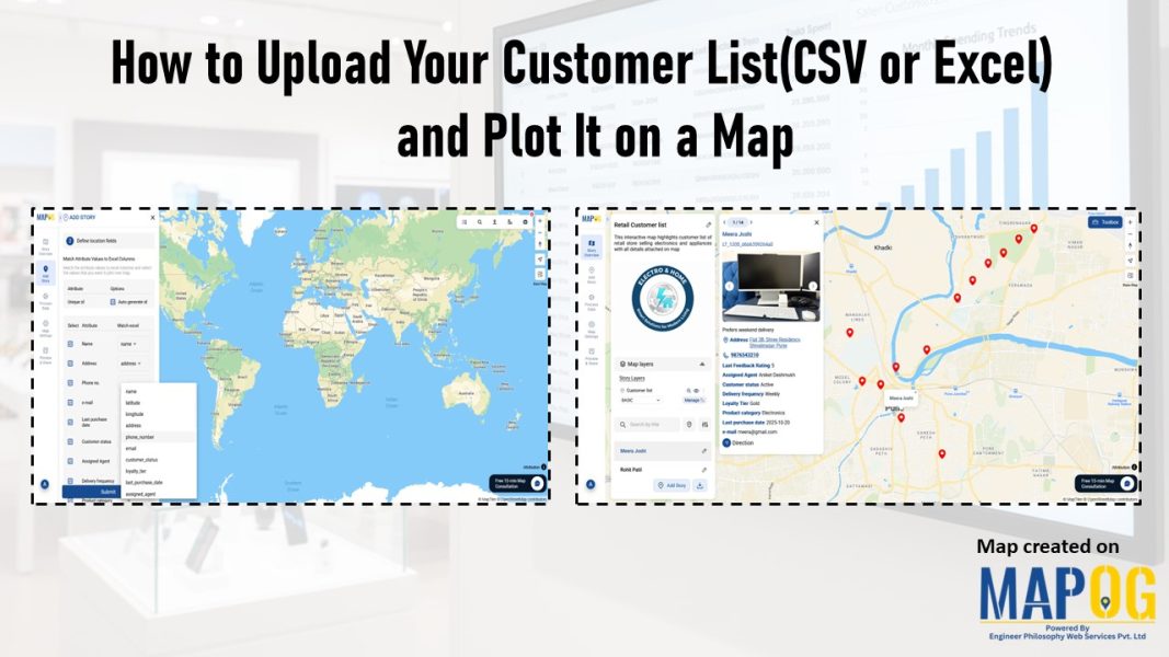
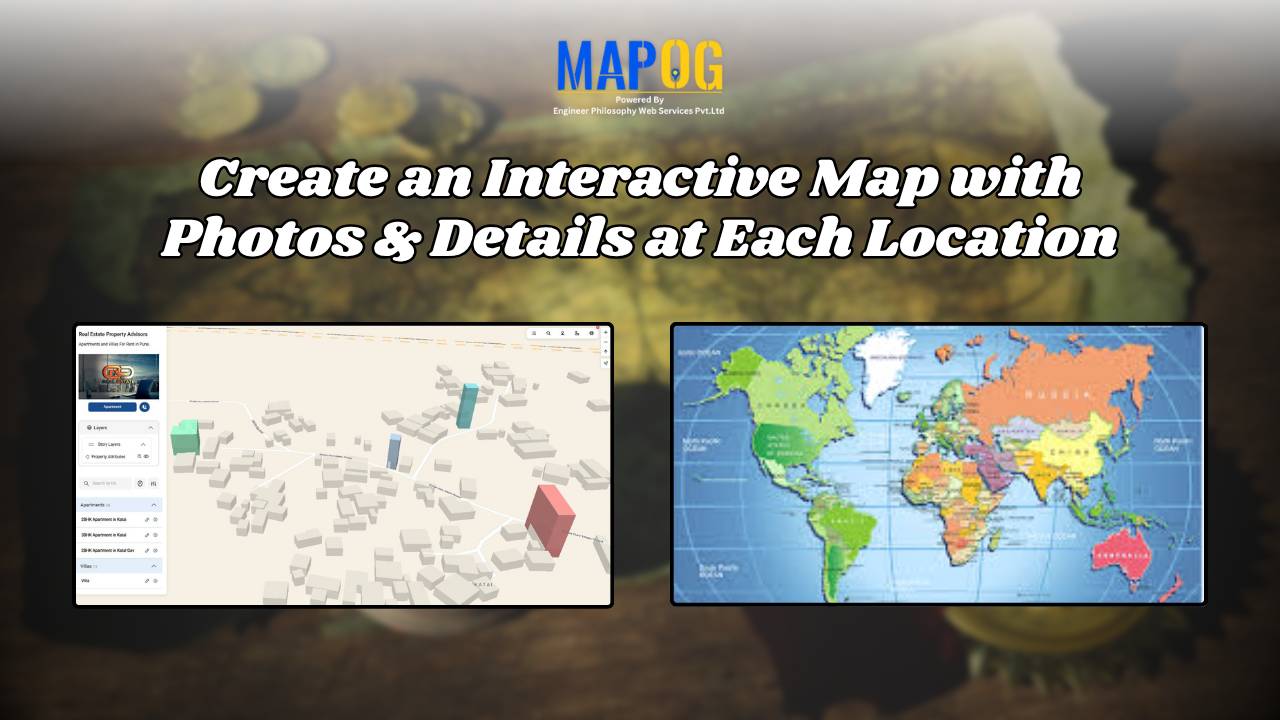
#GISMapping

Population Density Map by Districts

How To Create Population Density Map by Districts

Visualizing population density map by districts helps uncover patterns in urban growth, resource distribution, and planning needs. Whether you’re working on development plans, healthcare access, or disaster preparedness, mapping this data by district brings clarity that raw tables cannot. Thanks to MAPOG, users can create, style, and share interactive maps easily—no advanced GIS degree needed. … Read more

mapping sewage and drainage systems

Mapping Sewage and Drainage Systems Using Cross Intersection Tool

Nowadays, mapping sewage and drainage systems has become a smarter and more data-driven approach to urban planning and environmental safety. In particular, mapping such infrastructures helps identify pollution risks, optimise maintenance, and prevent disasters. One powerful way to achieve this is through the use of spatial tools like buffer zones and cross-intersection methods. By doing … Read more

Incredible India Itinerary: A Cultural Circuit on the Map

Incredible India Itinerary: A Cultural Circuit on the Map

India is a land of diverse cultures, rich heritage, and vibrant traditions. When you think of exploring the true essence of India, it’s not just about ticking off touristy landmarks; it’s about diving deep into the heart of its culture. In this guide, we’ll show you how to create an cultural circuit on map, connecting … Read more

Offbeat Travel in India Create Personalized Maps of Hidden Gems with MAPOG

Offbeat Travel in India: Create Personalized Maps of Hidden Gems

Nowadays, when traveling is about more than just checking places off a list, offbeat destinations in India offer a deeper and more meaningful experience for the curious traveler. With its vast cultural heritage and varied topography, India is home to countless hidden gems untouched by mass tourism. So, discovering these offbeat destinations in India isn’t … Read more

GIS helps in solar energy site suitability and analysis

How GIS helps in Solar Energy Site Suitability and Analysis

In today’s renewable energy movement, GIS helps in solar energy site suitability and analysis by providing precision, clarity, and data-driven decisions. This blog unpacks how Geographic Information Systems are transforming how we identify optimal solar farm locations, ensuring both efficiency and environmental harmony. Through a practical example using real GIS tools, you’ll discover how layered … Read more

Easiest Way to Create Interactive Maps — No Coding Required

Easiest Way to Create Interactive Maps — No Coding Required

Want to create interactive maps without coding? Whether you’re planning a road trip, showcasing local businesses, or working on a school project—interactive mapping has never been easier. With Story by MAPOG, anyone can build stunning, clickable maps to visualize places, add media, and share stories—no tech skills required. How to Create Interactive Maps Without Coding: … Read more

Virtual Tour Maps: Create Engaging, No-Code Experiences

Virtual Tour Maps: Create Engaging, No-Code Experiences

In an increasingly digital-first world, how we explore, explain, and experience places is changing rapidly. Today, virtual tour maps are not just tools for navigation—they’re powerful platforms for creating engaging, interactive experiences. Whether you’re in Tourism, Real Estate, Education, Retail , or Culture , virtual tours built with interactive maps are transforming how audiences engage … Read more

wildlife monitoring and prevention using gis tool

How to use GIS for Wildlife monitoring and prevention

As biodiversity faces unprecedented loss, conservationists are using advanced mapping technology to fight back. Geographic Information Systems (GIS) have evolved into powerful tools for wildlife monitoring and protection, enabling teams to plan migration corridors, predict poaching hotspots. This technology is empowering rangers and researchers to make faster, smarter decisions, helping reverse biodiversity loss. Key Concept … Read more

GIS in land use and zoning analysis for better city planning

GIS in Land use and Zoning analysis for better city planning

In today’s fast-changing urban landscape, GIS in land use and zoning analysis for better city planning plays a vital role in shaping smarter, more livable cities. Whether it’s managing population growth, conserving green spaces, or optimizing infrastructure, city planners increasingly depend on GIS to make informed decisions. This article explores how GIS tools enhance zoning … Read more